File proveniente da Wikimedia Commons. Clicca per visitare la pagina originale

File:Cohasset.jpg

Da Wikipedia, l'enciclopedia libera.
Vai alla navigazione Vai alla ricerca

File originale(4 627 × 3 142 pixel, dimensione del file: 2,95 MB, tipo MIME: image/jpeg)

Logo di Commons
Logo di Commons
Questo file e la sua pagina di descrizione (discussione · modifica) si trovano su Wikimedia Commons (?)

Dettagli

Questa è un'immagine di un luogo o edificio che è elencato nel National Register of Historic Places negli Stati Uniti. Il suo numero di riferimento è [https://npgallery.nps.gov/AssetDetail/NRIS/86001935 . 86001935 .].

Descrizione
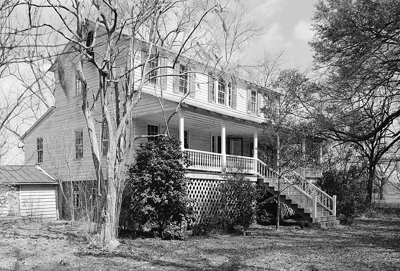
English: Cohasset, US 601, 1 mile North of Crocketville, Crocketville vicinity, Hampton County, SC. SOUTHEAST (FRONT) AND SOUTHWEST SIDE ELEVATIONS, LOOKING EAST. (From HABS: Built in 1873. Significance: Excellent example of Carolina I house, a vernacular house type popular from the late 18th through the early 20th century. Associated with William James Gooding, a cotton farmer who played a locally important role in politics and government. In addition, the property, which includes several late 19th century outbuildings and a late 19th century tenant house, is significant for information it reveals about post-Civil War agricultural practices.)
Data
Fonte

Historic American Buildings Survey,Library of Congress, Prints & Photographs Division, HABS [or HAER or HALS], Reproduction number "HABS SC,25-CROV.V,1-4"

Questa image è disponibile presso la Divisione Stampe e Fotografie (Prints and Photographs Division) della Biblioteca del Congresso sotto l'ID digitale hhh.sc0745.
Questo tag non indica lo status del copyright dell'opera ad esso associato. È quindi richiesto un normale tag di copyright. Vedi Commons:Licenze per maggiori informazioni.

العربية  беларуская (тарашкевіца)  বাংলা  čeština  Deutsch  English  español  فارسی  suomi  français  galego  עברית  magyar  Bahasa Indonesia  italiano  日本語  lietuvių  македонски  മലയാളം  Nederlands  polski  português  português do Brasil  română  русский  sicilianu  slovenčina  slovenščina  Türkçe  українська  简体中文  繁體中文  +/−

Autore
Jack E. Boucher  (1931–2012)  wikidata:Q6111338
 
Nomi alternativi
Jack E. Boucher; Jack Edward Boucher
Descrizione fotografo e fotografo d'architettura statunitense
HABS, HAER and HALS photographer, National Park Service
Data di nascita/morte 4 settembre 1931 Modifica su Wikidata 2 settembre 2012 Modifica su Wikidata
Luogo di nascita/morte Buffalo Holy Cross Hospital
Periodo di attività dal 1949 al 2009
Luogo di attività
Authority file
creator QS:P170,Q6111338
Licenza
(Riusare questo file)
This file comes from the Historic American Buildings Survey (HABS), Historic American Engineering Record (HAER) or Historic American Landscapes Survey (HALS). These are programs of the National Park Service established for the purpose of documenting historic places. Records consist of measured drawings, archival photographs, and written reports.


When reusing please credit: Library of Congress, Prints & Photographs Division, SC-601-4
Questo tag non indica lo status del copyright dell'opera ad esso associato. È quindi richiesto un normale tag di copyright. Vedi Commons:Licenze per maggiori informazioni.

Public domain This image or media file contains material based on a work of a National Park Service employee, created as part of that person's official duties. As a work of the U.S. federal government, such work is in the public domain in the United States. See the NPS website and NPS copyright policy for more information.
Posizione del soggetto32° 55′ 55″ N, 81° 04′ 40″ W Kartographer map based on OpenStreetMap.Posizione di questa e altre immagini su: OpenStreetMapinfo

Didascalie

Aggiungi una brevissima spiegazione di ciò che questo file rappresenta

Elementi ritratti in questo file

raffigura

Cohasett inglese

32°55'54.998"N, 81°4'40.001"W

image/jpeg

98d9708f05d07335c24c4e7c801bb5c1143cac45

3 091 200 byte

3 142 pixel

4 627 pixel

Cronologia del file

Fare clic su un gruppo data/ora per vedere il file come si presentava nel momento indicato.

Data/OraMiniaturaDimensioniUtenteCommento
attuale19:24, 26 mar 2009Miniatura della versione delle 19:24, 26 mar 20094 627 × 3 142 (2,95 MB)Martin H.High res; cropped
22:48, 10 ott 2008Miniatura della versione delle 22:48, 10 ott 2008935 × 648 (580 KB)Altairisfar== Summary == {{Information |Description={{en|Cohasset, US 601, 1 mile North of Crocketville, Crocketville vicinity, Hampton County, SC. SOUTHEAST (FRONT) AND SOUTHWEST SIDE ELEVATIONS, LOOKING EAST. (From HABS: Built in 1873. Significance: Excellent ex

La seguente pagina usa questo file:

Utilizzo globale del file

Anche i seguenti wiki usano questo file:

Metadati