File:British Guiana - 1908 - WDL.png
Vai alla navigazione
Vai alla ricerca

Dimensioni di questa anteprima: 376 × 600 pixel. Altre risoluzioni: 150 × 240 pixel | 301 × 480 pixel | 481 × 768 pixel | 642 × 1 024 pixel | 1 283 × 2 048 pixel | 4 080 × 6 510 pixel.
File originale (4 080 × 6 510 pixel, dimensione del file: 32,48 MB, tipo MIME: image/png)
| Questo file e la sua pagina di descrizione (discussione · modifica) si trovano su Wikimedia Commons (?) |
Dettagli
| Descrizione |
English: British Guiana, 1908
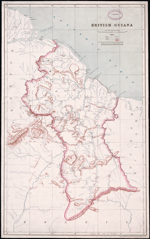
Creator: Great Britain. Ordnance Survey Surveyor: Anderson, Charles Wilgress "This map, prepared and printed in 1908 at the office of the Ordnance Survey, Southampton, United Kingdom, provides a relatively detailed view of the geography of British Guiana (present-day Guyana), one of only two British colonies on the mainland of South and Central America (the other being British Honduras). A note indicates that the portion of the map north of 5° North latitude is from a map prepared by the government surveyor of British Guiana, while the remainder of the map “has been compiled from various sources and is less reliable.” Much of the territory in the south of the country was as yet unexplored. Bordered to the west by Venezuela, to the south by Brazil, and to the east by Dutch Guiana (present-day Suriname), British Guiana was the subject of a longstanding border dispute with Venezuela, in which the United States became involved and that was settled by arbitration in 1899. The map reflects the settlement, which awarded Britain most of the disputed territory but gave Venezuela undisputed control over the Orinoco River. The map shows international borders, cities and towns, railroads, posts and forts, and physical features such as rivers, cataracts, and hills and mountains." |
| Data | |
| Fonte | http://www.wdl.org/en/item/11328/ |
| Autore | Great Britain. Ordnance Survey |
Licenza
Questo file è nel pubblico dominio negli Stati Uniti. Questo si applica alle opere statunitensi il cui copyright è scaduto, spesso perché la sua prima pubblicazione è avvenuta prima del 1º gennaio 1929. Vedi questa pagina per ulteriori spiegazioni.
|
 | |
 |
Questa immagine potrebbe non essere nel pubblico dominio al di fuori degli Stati Uniti, in particolare nei Paesi e nelle aree in cui non viene applicata la regola della durata più breve per le opere statunitensi, come in Canada, Cina (non a Hong Kong, Macao o Taiwan), Germania, Messico e Svizzera. Il creatore e l’anno di pubblicazione sono informazioni essenziali e devono essere fornite. Vedi Wikipedia:Public domain e Wikipedia:Copyright per maggiori dettagli.
|
Cronologia del file
Fare clic su un gruppo data/ora per vedere il file come si presentava nel momento indicato.
| Data/Ora | Miniatura | Dimensioni | Utente | Commento | |
|---|---|---|---|---|---|
| attuale | 10:58, 18 gen 2020 | | 4 080 × 6 510 (32,48 MB) | ZiaLater | More detailed version |
| 22:39, 23 ott 2013 |  | 1 024 × 1 631 (2,71 MB) | SarahStierch | User created page with UploadWizard |
Pagine che usano questo file
La seguente pagina usa questo file:
Utilizzo globale del file
Anche i seguenti wiki usano questo file:
- Usato nelle seguenti pagine di en.wikipedia.org:
- Usato nelle seguenti pagine di eo.wikipedia.org:
- Usato nelle seguenti pagine di es.wikipedia.org:
- Usato nelle seguenti pagine di fa.wikipedia.org:
- Usato nelle seguenti pagine di fr.wikipedia.org:
- Usato nelle seguenti pagine di he.wikipedia.org:
- Usato nelle seguenti pagine di hr.wikipedia.org:
- Usato nelle seguenti pagine di is.wikipedia.org:
- Usato nelle seguenti pagine di ms.wikipedia.org:
- Usato nelle seguenti pagine di pt.wikipedia.org:
- Usato nelle seguenti pagine di ru.wikipedia.org:
- Usato nelle seguenti pagine di zh.wikipedia.org: