File:Bravo fallout2.png
Vai alla navigazione
Vai alla ricerca
Dimensioni di questa anteprima: 800 × 364 pixel. Altre risoluzioni: 320 × 146 pixel | 928 × 422 pixel.
File originale (928 × 422 pixel, dimensione del file: 23 KB, tipo MIME: image/png)
| Questo file e la sua pagina di descrizione (discussione · modifica) si trovano su Wikimedia Commons (?) |
Dettagli
| Descrizione |
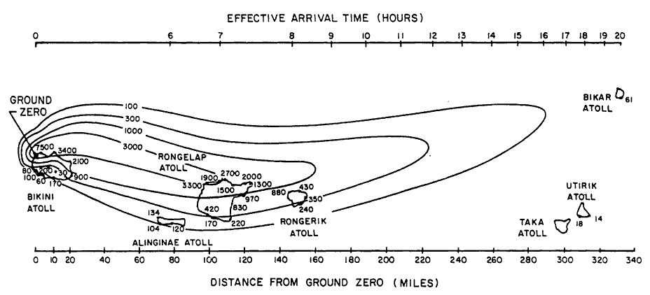
English: Path of nuclear fallout plume after U.S. nuclear weapons test Bravo (yield 15 Mt) on Bikini Atoll. It is the single worst contamination accident in U.S. nuclear history. The test was part of the Operation Castle. The Bravo event was an experimental thermonuclear device surface event. The numbers correspond with estimated total (accumulated) dose contours (rad).
Suomi: Ydinkoe Bravon (räjähdysvoima 15 Mt) radioaktiivinen laskeuma. Bravo testi on Yhdysvaltojen pahin ydinonnettomuus. Testi oli osa Operaatio Castlea. Bravo räjäytys oli kokeellinen fuusioreaktioon perustuva pintaräjäytys Bikinin atollilla. Kuvan numerot kuvaavat arvioituja kertyneen kokonaislaskeuman rajoja (rad). |
| Data | |
| Fonte | Samuel Glasstone and Phillip J. Dolan, eds., The Effects of Nuclear Weapons, 3rd. edn. (Washington, D.C.: DOD and DOE, 1977): 437. [Gamma doses are Roentgens from arrival time to 96 hours (4 days) after detonation, outside on land. Glasstone and Dolan mention that because data from the ocean was not obtained in this particular test, Bravo, the fallout contours to the north of the islands are uncertain and some other fallout patterns for the same test ascribe the high levels measured on Rongelap to a "hotspot" of the sort measured in the ocean downwind in later tests. |
| Autore | United States Department of Energy |
| Altre versioni |
 |

|
Questa immagine (categorizzazione automatica: graph) o tutte le immagini in questa categoria o galleria dovrebbero essere ricreate usando grafica vettoriale come file SVG. Questo offre diversi vantaggi: vedi Commons:Media for cleanup per maggiori informazioni. Se è disponibile una versione in formato SVG di questa immagine, per favore caricala. Dopo aver caricato un file SVG, sostituisci questo avviso con il template {{Vector version available|nome_immagine.svg}}.
|
Licenza
| This image is a work of a United States Department of Energy (or predecessor organization) employee, taken or made as part of that person's official duties. As a work of the U.S. federal government, the image is in the public domain.
Please note that national laboratories operate under varying licences and some are not free. Check the site policies of any national lab before crediting it with this tag.
|

|
Cronologia del file
Fare clic su un gruppo data/ora per vedere il file come si presentava nel momento indicato.
| Data/Ora | Miniatura | Dimensioni | Utente | Commento | |
|---|---|---|---|---|---|
| attuale | 19:25, 10 dic 2005 | | 928 × 422 (23 KB) | Fastfission~commonswiki | Image of nuclear fallout dispersal from the Castle Bravo nuclear test, 28 Feb 1954. ==Licensing== *Source: Samuel Glasstone and Phillip J. Dolan, eds., ''The Effects of Nuclear Weapons'', 3rd. edn. (Washington, D.C.: DOD and DOE, 1977): 437. {{PD-USG |
Pagine che usano questo file
La seguente pagina usa questo file:
Utilizzo globale del file
Anche i seguenti wiki usano questo file:
- Usato nelle seguenti pagine di cs.wikipedia.org:
- Usato nelle seguenti pagine di de.wikipedia.org:
- Usato nelle seguenti pagine di en.wikipedia.org:
- Usato nelle seguenti pagine di en.wikiquote.org:
- Usato nelle seguenti pagine di es.wikipedia.org:
- Usato nelle seguenti pagine di fr.wikipedia.org:
- Usato nelle seguenti pagine di hr.wikipedia.org:
- Usato nelle seguenti pagine di ja.wikipedia.org:
- Usato nelle seguenti pagine di ko.wikipedia.org:
- Usato nelle seguenti pagine di la.wikipedia.org:
- Usato nelle seguenti pagine di pl.wikipedia.org:
- Usato nelle seguenti pagine di pt.wikipedia.org:
- Usato nelle seguenti pagine di ru.wikipedia.org:
- Usato nelle seguenti pagine di sh.wikipedia.org:
- Usato nelle seguenti pagine di sk.wikipedia.org:
- Usato nelle seguenti pagine di sl.wikipedia.org:
- Usato nelle seguenti pagine di sr.wikipedia.org:
- Usato nelle seguenti pagine di te.wikipedia.org:
- Usato nelle seguenti pagine di uk.wikipedia.org:
- Usato nelle seguenti pagine di zh.wikipedia.org: