File:Asia Europe transcontinental.png
Vai alla navigazione
Vai alla ricerca

Dimensioni di questa anteprima: 763 × 599 pixel. Altre risoluzioni: 306 × 240 pixel | 611 × 480 pixel | 978 × 768 pixel | 1 268 × 996 pixel.
File originale (1 268 × 996 pixel, dimensione del file: 46 KB, tipo MIME: image/png)
| Questo file e la sua pagina di descrizione (discussione · modifica) si trovano su Wikimedia Commons (?) |
| Descrizione |
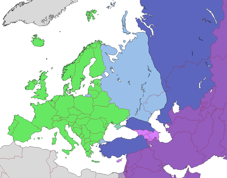
English: Map of Europe, indicating continental boundary (by Britannica and Great Soviet Encyclopedia) and transcontinental states.
States geographically in Europe (excepting overseas possessions)
Transcontinental states, European territory
Transcontinental states, Asian territory
Asian countries, sometimes referred to as Europe according to political, economic, and historical and cultural criteria (Azerbaijan, Armenia, Georgia, Cyprus)
Geographically Asian states (island states of Cyprus and Bahrain usually grouped with Asia geographically)
Asian part of Egypt Русский: Карта Европы с указанием границ частей света (по БСЭ и Британнике) и трансконтинентальных государств.
Государства, расположенные в Европе (за исключением заморских владений)
Трансконтинентальные государства, европейская территория
Трансконтинентальные государства, азиатская территория
Государства Азии, иногда относимые к Европе по политическим, экономическим, и историко-культурным критериям
Государства, расположенные в Азии
Азиатская часть Египта |
| Data | |
| Fonte | |
| Autore |
.png)
Licenza
Questo file è disponibile in base alla licenza Creative Commons Attribuzione-Condividi allo stesso modo 3.0 Unported
- Tu sei libero:
- di condividere – di copiare, distribuire e trasmettere quest'opera
- di modificare – di adattare l'opera
- Alle seguenti condizioni:
- attribuzione – Devi fornire i crediti appropriati, un collegamento alla licenza e indicare se sono state apportate modifiche. Puoi farlo in qualsiasi modo ragionevole, ma non in alcun modo che suggerisca che il licenziante approvi te o il tuo uso.
- condividi allo stesso modo – Se remixi, trasformi o sviluppi il materiale, devi distribuire i tuoi contributi in base alla stessa licenza o compatibile all'originale.
| Annotazioni | Questa immagine è annotata: Vedi le annotazioni su Commons |
Cronologia del file
Fare clic su un gruppo data/ora per vedere il file come si presentava nel momento indicato.
| Data/Ora | Miniatura | Dimensioni | Utente | Commento | |
|---|---|---|---|---|---|
| attuale | 12:23, 14 nov 2022 | | 1 268 × 996 (46 KB) | Рагин1987 | Highlighted with a light purple hue the countries of Asia, sometimes attributed to Europe according to political, economic, and historical and cultural criteria (Transcaucasia, Cyprus). |
| 14:02, 29 ago 2022 |  | 1 268 × 996 (46 KB) | Рагин1987 | Small correction | |
| 09:03, 18 feb 2020 |  | 1 268 × 996 (56 KB) | Insider | fix: mixed color. not dark blue | |
| 08:55, 18 feb 2020 |  | 1 268 × 996 (60 KB) | Insider | Reverted to version as of 07:01, 13 October 2014 (UTC) Crimea that is Europe | |
| 11:04, 10 feb 2020 |  | 1 268 × 996 (84 KB) | Compu wiki | Крым — это Россия. Crimea is Russia. | |
| 09:01, 13 ott 2014 |  | 1 268 × 996 (60 KB) | Insider | Reverted to version as of 10:10, 1 July 2014 Crimea that is Europe | |
| 14:31, 11 ott 2014 |  | 1 268 × 996 (84 KB) | Michael1238 | Crimea | |
| 12:10, 1 lug 2014 |  | 1 268 × 996 (60 KB) | Insider | {{Information |Description={{en|1= Map of Europe, indicating continental boundary and transcontinental states. {{legend|#67e836|States geographically in Europe (excepting overseas possessions; island states UK, Ireland, Iceland and Malta usually group... |
Pagine che usano questo file
Nessuna pagina utilizza questo file.
Utilizzo globale del file
Anche i seguenti wiki usano questo file:
- Usato nelle seguenti pagine di hy.wikipedia.org:
- Usato nelle seguenti pagine di kk.wikipedia.org:
- Usato nelle seguenti pagine di ru.wikipedia.org: