File:1948 Jerusalem Bevingrad Princess Mary Ave.jpg

File originale (985 × 716 pixel, dimensione del file: 236 KB, tipo MIME: image/jpeg)
| Questo file e la sua pagina di descrizione (discussione · modifica) si trovano su Wikimedia Commons (?) |
| Descrizione |
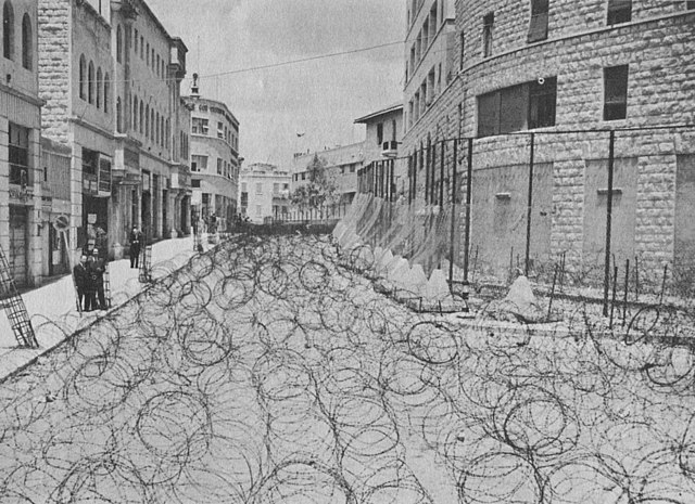
1948. Jerusalem, Princess Mary Ave. (now, ShlomTsiyon HaMalka St.) at the corner with Coresh street (aka Koresh) The British Mandatory administration used barbed wire to block the area (dubbed "Bevingrad") from both Jewish and Arab traffic. The building on the right was police HQ. It is today still called the Generali Building after the Assicurazioni Generali insurance company of Italy, which built it in 1935. |
| Data | |
| Fonte | To the Promised Land by Uri Dan. Doubleday, 1988. p.114 |
| Autore | Sconosciuto |
| Luogo dello scatto | | Posizione di questa e altre immagini su: OpenStreetMap |
|---|
Present Day Google Street View: ShlomTsiyon HaMalka St., cor. Koresh St. (on right), looking NNW toward Jaffa Rd.
This work or image is now in the public domain because its term of copyright has expired in Israel (details). According to Israel's copyright statute from 2007 (translation), a work is released to the public domain on 1 January of the 71st year after the author's death (paragraph 38 of the 2007 statute) with the following exceptions:
|
 |
Cronologia del file
Fare clic su un gruppo data/ora per vedere il file come si presentava nel momento indicato.
| Data/Ora | Miniatura | Dimensioni | Utente | Commento | |
|---|---|---|---|---|---|
| attuale | 12:26, 15 mar 2007 | | 985 × 716 (236 KB) | Humus sapiens~commonswiki | {{Information |Description=1948. Jerusalem, Princess Mary Ave. The building on the right is police HQ. The British Mandatory administration used barbed wire to block the area (dubbed "Bevingrad") from both Jewish and Arab traffic. |Source=''To the Promis |
Pagine che usano questo file
La seguente pagina usa questo file:
Utilizzo globale del file
Anche i seguenti wiki usano questo file:
- Usato nelle seguenti pagine di ar.wikipedia.org:
- Usato nelle seguenti pagine di cs.wikipedia.org:
- Usato nelle seguenti pagine di en.wikipedia.org:
- Usato nelle seguenti pagine di es.wikipedia.org:
- Usato nelle seguenti pagine di he.wikipedia.org:
- בווינגרד
- רחוב שלומציון המלכה
- פורטל:היישוב/תמונה נבחרת/גלריה
- פורטל:ירושלים/הידעת?/קטעי הידעת?
- פורטל:היישוב/תמונה נבחרת/20
- פורטל:היישוב/הידעת?/קטעי הידעת? - 1
- פורטל:היישוב/הידעת?/38
- פורטל:ירושלים/הידעת?/37
- ירושלים בתקופת המנדט הבריטי
- משטרת המנדט
- פורטל:תולדות עם ישראל/היום בתולדות עם ישראל/שבט
- פורטל:תולדות עם ישראל/היום בתולדות עם ישראל/י' בשבט
- פורטל:רוסיה/הידעת?/קטעי הידעת?
- פורטל:רוסיה/הידעת?/48
- Usato nelle seguenti pagine di zh.wikipedia.org: