File:Whitsunday Islands, Queensland, Australia.jpg
Vai alla navigazione
Vai alla ricerca

Dimensioni di questa anteprima: 480 × 600 pixel. Altre risoluzioni: 192 × 240 pixel | 384 × 480 pixel | 614 × 768 pixel | 819 × 1 024 pixel | 1 638 × 2 048 pixel | 4 000 × 5 000 pixel.
File originale (4 000 × 5 000 pixel, dimensione del file: 3,43 MB, tipo MIME: image/jpeg)
| Questo file e la sua pagina di descrizione (discussione · modifica) si trovano su Wikimedia Commons (?) |
Dettagli
| Descrizione |
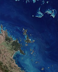
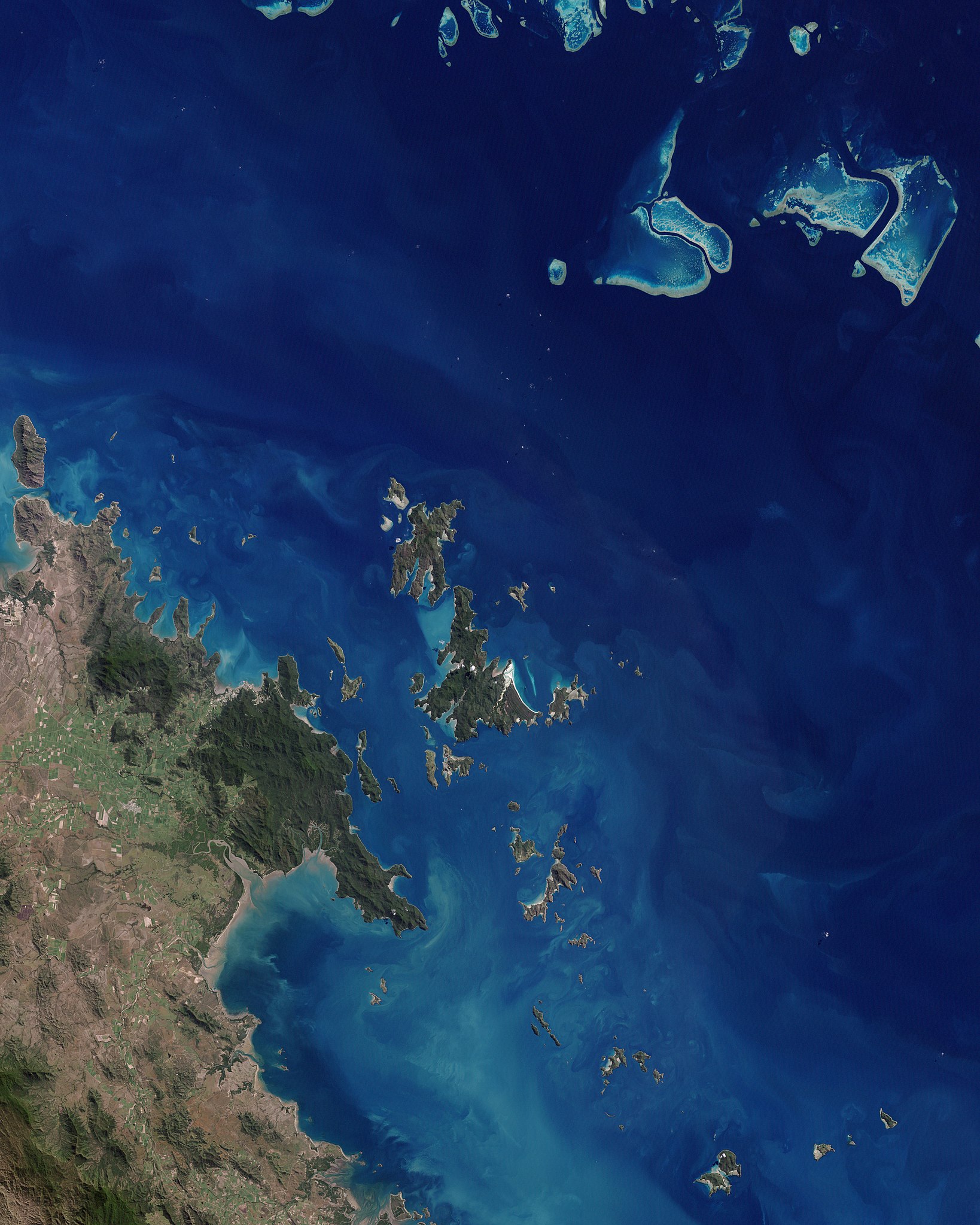
English: This scene is dominated by the largest island and namesake of the chain. Deep green forest covers most of Whitsunday Island, which is outlined by brilliant white sand beaches, the largest and most dramatic being Whitehaven Beach at the south-eastern end of the island. On Hamilton Island, the strong linear feature at the southern end shows where a jet-accessible runway was added to allow airlines from major Australian cities to fly directly to the islands. The swirls of pale blue around the islands show a mix of sandy bottom waters and shallow, fringing coral reefs. The green land in the south-western corner of the image is a small section of Conway Ranges National Park, on the shoreline of mainland Queensland.
Deutsch: Dieses photoähnliche Bild des Kerns der Whitsunday Islands wurde am 22. Mai 2003 mit dem Enhanced Thematic Mapper Plus (ETM+) des Landsat 7 erstellt. Das Bild wird von der größten Insel und Namensgeberin für die gesamte Inselgruppe dominiert. Den größtem Teil der Whitsunday Island bedecken tiefgrüne Wälder, die von brillanten weißen Sandstränden eingerahmt werden – der größte unter ihnen ist Whitehaven Beach im Südosten der Insel. |
| Data | |
| Fonte | NASA Earth Observatory |
| Autore | Jesse Allen |
| Altre versioni | File:Whitsunday Islands Landsat 7 with some captions.jpg |
Image acquired by the Enhanced Thematic Mapper Plus (ETM+) instrument on NASA’s Landsat 7 satellite. Landsat data provided by the United States Geological Survey.
Licenza
| Questo file è nel pubblico dominio perché creato dalla NASA. La politica sul copyright della NASA afferma che «il materiale della NASA non è protetto da copyright a meno che non sia specificato altrimenti». (NASA copyright policy e JPL Image Use Policy). | ||
 |
Attenzione:
|
| Annotazioni | Questa immagine è annotata: Vedi le annotazioni su Commons |
Cronologia del file
Fare clic su un gruppo data/ora per vedere il file come si presentava nel momento indicato.
| Data/Ora | Miniatura | Dimensioni | Utente | Commento | |
|---|---|---|---|---|---|
| attuale | 14:26, 7 gen 2010 | | 4 000 × 5 000 (3,43 MB) | Originalwana | {{Information |Description={{en|1=This scene is dominated by the largest island and namesake of the chain. Deep green forest covers most of Whitsunday Island, which is outlined by brilliant white sand beaches, the largest and most dramatic being Whitehave |
Pagine che usano questo file
La seguente pagina usa questo file:
Utilizzo globale del file
Anche i seguenti wiki usano questo file:
- Usato nelle seguenti pagine di af.wikipedia.org:
- Usato nelle seguenti pagine di be.wikipedia.org:
- Usato nelle seguenti pagine di en.wikipedia.org:
- Usato nelle seguenti pagine di eo.wikipedia.org:
- Usato nelle seguenti pagine di mr.wikipedia.org:
- Usato nelle seguenti pagine di nl.wikipedia.org:
- Usato nelle seguenti pagine di pl.wikipedia.org:
- Usato nelle seguenti pagine di ru.wikipedia.org:
- Usato nelle seguenti pagine di zh.wikipedia.org: