File:Tonlesap.jpg
Vai alla navigazione
Vai alla ricerca
Dimensioni di questa anteprima: 597 × 599 pixel. Altre risoluzioni: 239 × 240 pixel | 478 × 480 pixel | 765 × 768 pixel | 1 020 × 1 024 pixel | 2 039 × 2 048 pixel | 4 079 × 4 096 pixel.
File originale (4 079 × 4 096 pixel, dimensione del file: 17,17 MB, tipo MIME: image/jpeg)
| Questo file e la sua pagina di descrizione (discussione · modifica) si trovano su Wikimedia Commons (?) |
| Descrizione |
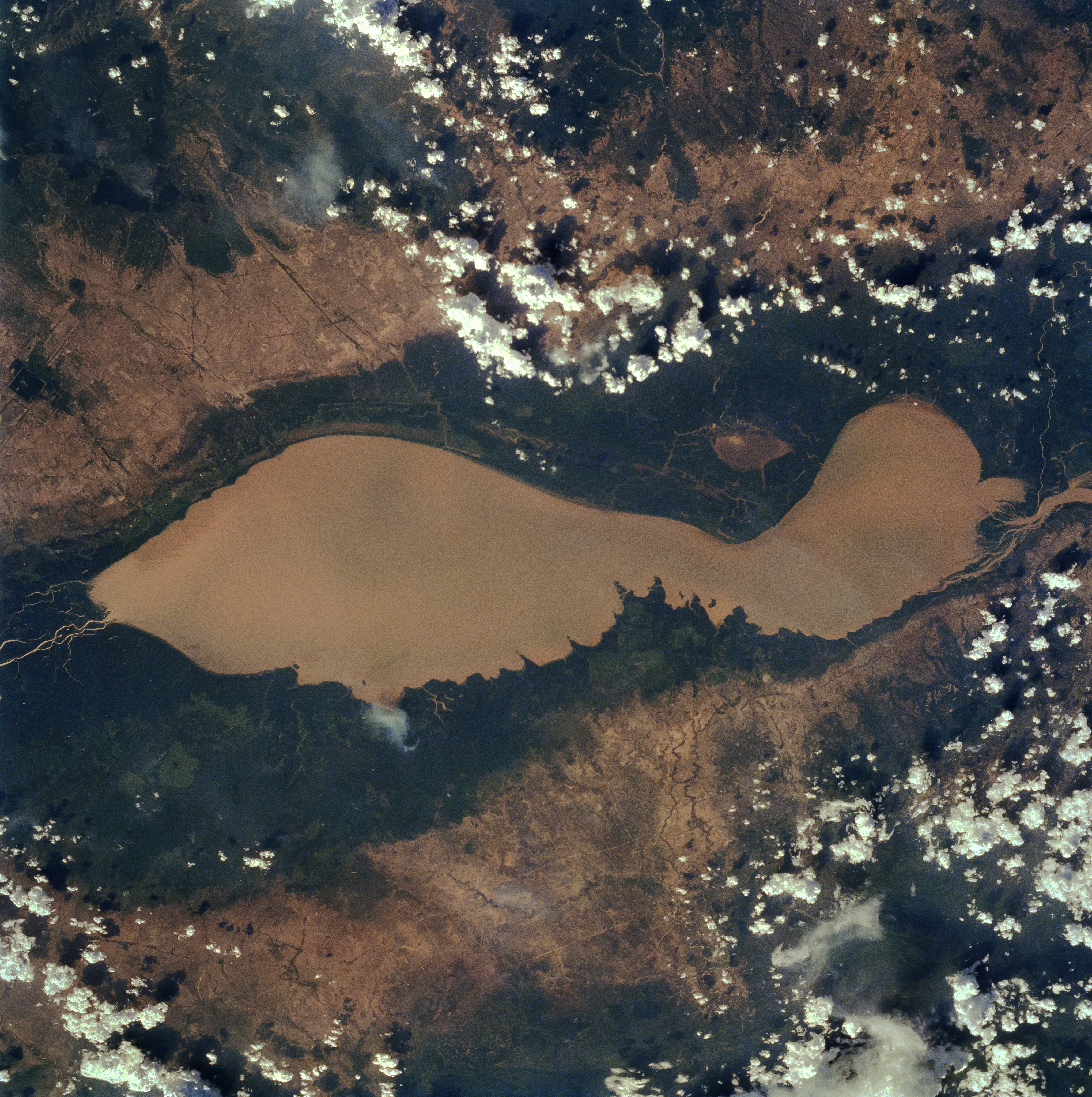
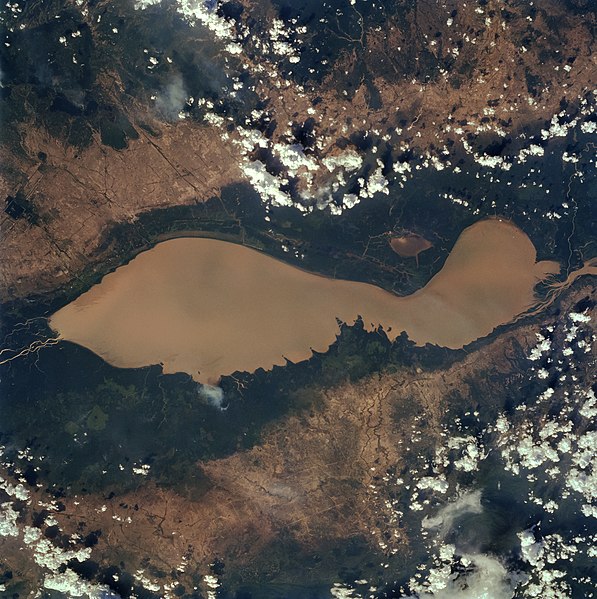
English: The Tonle Sap (also know as the Great Lake) occupies a depression in the Cambodian Plain and is a shallow silt-laden lake. It is the largest lake in Southeast Asia and is fed by many streams. The Tonle Sap is drained by the Tonle Sab River (upper center), which flows south-southeast to the Mekong River (not visible on the image). The river connecting the Tonle Sap with the Mekong creates a unique phenomenon not known in any other part of the world: reversing its direction of flow twice a year. For most of the time, the Tonle Sab River flows from the lake to the Mekong River near the capital city of Phnom Penh. However, during the Southeast Asian monsoon season from June to November, when the Mekong drains large areas of Southeast Asia, the Tonle Sab flows from the Mekong back into the Tonle Sap. During the monsoon season, the Tonle Sap increases from 1000 sq. miles (2600 sq. km) to near 4020 sq. miles (10400 sq. km) raising the lake level 30 feet (9 meters), causing enormous floods in the region surrounding the lake. |
| Data | |
| Fonte |
Earth from Space - Image Information Gateway to Astronaut Photography of Earth |
| Autore | NASA/Johnson Space Center |
| Licenza (Riusare questo file) |
PD-USGov-NASA |
Questa immagine o filmato è stato catalogato da uno dei centri della National Aeronautics and Space Administration (NASA) degli Stati Uniti d'Americacon il Photo ID: STS059-84-80.Questo tag non indica lo status del copyright dell'opera ad esso associato. È quindi richiesto un normale tag di copyright. Vedi Commons:Licenze per maggiori informazioni. Altre lingue:
|
| Questo file è nel pubblico dominio perché creato dalla NASA. La politica sul copyright della NASA afferma che «il materiale della NASA non è protetto da copyright a meno che non sia specificato altrimenti». (NASA copyright policy e JPL Image Use Policy). | ||
 |
Attenzione:
|
Cronologia del file
Fare clic su un gruppo data/ora per vedere il file come si presentava nel momento indicato.
| Data/Ora | Miniatura | Dimensioni | Utente | Commento | |
|---|---|---|---|---|---|
| attuale | 12:40, 4 apr 2022 | | 4 079 × 4 096 (17,17 MB) | Tiouraren | larger version |
| 08:48, 15 lug 2015 |  | 902 × 695 (293 KB) | Wikirictor | i re-sized it, enhanced its quality and rotated it in order to have north on top. | |
| 07:04, 18 giu 2006 |  | 637 × 640 (53 KB) | Georgio~commonswiki | {{Information |Description=Earth Sciences and Image Analysis, NASA-Johnson Space Center. 16 Apr. 2004. "Earth from Space - Image Information." |Source=http://earth.jsc.nasa.gov/sseop/efs/photoinfo.pl?PHOTO=STS059-84-80 |Date=16 Apr. 2004. |Author=NASA |Pe |
Pagine che usano questo file
La seguente pagina usa questo file:
Utilizzo globale del file
Anche i seguenti wiki usano questo file:
- Usato nelle seguenti pagine di af.wikipedia.org:
- Usato nelle seguenti pagine di ar.wikipedia.org:
- Usato nelle seguenti pagine di az.wikipedia.org:
- Usato nelle seguenti pagine di bg.wikipedia.org:
- Usato nelle seguenti pagine di ca.wikipedia.org:
- Usato nelle seguenti pagine di ceb.wikipedia.org:
- Usato nelle seguenti pagine di cv.wikipedia.org:
- Usato nelle seguenti pagine di cy.wikipedia.org:
- Usato nelle seguenti pagine di en.wikipedia.org:
- Usato nelle seguenti pagine di en.wikivoyage.org:
- Usato nelle seguenti pagine di eo.wikipedia.org:
- Usato nelle seguenti pagine di es.wikipedia.org:
- Usato nelle seguenti pagine di eu.wikipedia.org:
- Usato nelle seguenti pagine di he.wikivoyage.org:
- Usato nelle seguenti pagine di id.wikipedia.org:
- Usato nelle seguenti pagine di it.wikivoyage.org:
- Usato nelle seguenti pagine di ja.wikipedia.org:
- Usato nelle seguenti pagine di ka.wikipedia.org:
- Usato nelle seguenti pagine di ko.wikipedia.org:
- Usato nelle seguenti pagine di ms.wikipedia.org:
- Usato nelle seguenti pagine di my.wikipedia.org:
- Usato nelle seguenti pagine di no.wikipedia.org:
- Usato nelle seguenti pagine di pl.wikipedia.org:
- Usato nelle seguenti pagine di ru.wikipedia.org:
- Usato nelle seguenti pagine di sh.wikipedia.org:
- Usato nelle seguenti pagine di sv.wikipedia.org:
- Usato nelle seguenti pagine di te.wikipedia.org:
- Usato nelle seguenti pagine di th.wikipedia.org:
- Usato nelle seguenti pagine di tl.wikipedia.org:
- Usato nelle seguenti pagine di uk.wikipedia.org:
- Usato nelle seguenti pagine di ur.wikipedia.org:
- Usato nelle seguenti pagine di vi.wikipedia.org:
- Usato nelle seguenti pagine di war.wikipedia.org:
- Usato nelle seguenti pagine di www.wikidata.org:
- Usato nelle seguenti pagine di zh-yue.wikipedia.org:
- Usato nelle seguenti pagine di zh.wikipedia.org: