File:Satellite image of Hokkaido, Japan in January 2003.jpg
Vai alla navigazione
Vai alla ricerca

Dimensioni di questa anteprima: 471 × 599 pixel. Altre risoluzioni: 188 × 240 pixel | 377 × 480 pixel | 603 × 768 pixel | 804 × 1 024 pixel | 2 200 × 2 800 pixel.
File originale (2 200 × 2 800 pixel, dimensione del file: 1,74 MB, tipo MIME: image/jpeg)
| Questo file e la sua pagina di descrizione (discussione · modifica) si trovano su Wikimedia Commons (?) |
Dettagli
Dettagli
| Descrizione |
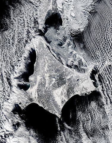
English: Satellite image of Hokkaido, Japan in January 2003. This stunning true-color image shows clouds surrounding northern Japan’s snow-dusted Hokkaido Island in between the black waters of two seas and an ocean. Hokkaido Island is home to the city of Sapporo, which is located on the lower western side near where the island’s tail begins to curve south toward the main island of Japan (middle lower left) and not far from the Ishikari-wan, the north-facing bay that has a streak of clouds moving horizontally across it. Hokkaido’s northern point reaches toward the Russian island of Sakhalin (top center), while the eastern point stretches toward the Kuril Islands, a volcanic chain that eventually connects to the Russian Kamchatka Peninsula. Between Hokkaido’s northern and eastern points lies the southern reaches of the Sea of Okhotsk (upper right), while the northern and southern points lie along the Sea of Japan. From its southern to eastern point, the Pacific Ocean laps at Hokkaido’s shores. This Aqua MODIS image was acquired January 15, 2003. |
| Data | |
| Fonte | NASA's Visible Earth http://visibleearth.nasa.gov/view_rec.php?id=4720 |
| Autore | NASA's Visible Earth |
Licenza
| Questo file è nel pubblico dominio perché creato dalla NASA. La politica sul copyright della NASA afferma che «il materiale della NASA non è protetto da copyright a meno che non sia specificato altrimenti». (NASA copyright policy e JPL Image Use Policy). | ||
 |
Attenzione:
|
Cronologia del file
Fare clic su un gruppo data/ora per vedere il file come si presentava nel momento indicato.
| Data/Ora | Miniatura | Dimensioni | Utente | Commento | |
|---|---|---|---|---|---|
| attuale | 00:02, 8 mag 2006 | | 2 200 × 2 800 (1,74 MB) | Akanemoto~commonswiki | Satellite image of Hokkaido, Japan in January 2003. Taken from NASA's Visible Earth http://visibleearth.nasa.gov/view_rec.php?id=4720 : This stunning true-color image shows clouds surrounding northern Japan’s snow-dusted Hokkaido Island in between the |
Pagine che usano questo file
La seguente pagina usa questo file:
Utilizzo globale del file
Anche i seguenti wiki usano questo file:
- Usato nelle seguenti pagine di ast.wikipedia.org:
- Usato nelle seguenti pagine di az.wikipedia.org:
- Usato nelle seguenti pagine di ba.wikipedia.org:
- Usato nelle seguenti pagine di en.wikipedia.org:
- Usato nelle seguenti pagine di es.wikipedia.org:
- Usato nelle seguenti pagine di id.wikipedia.org:
- Usato nelle seguenti pagine di ja.wikipedia.org:
- Usato nelle seguenti pagine di km.wikipedia.org:
- Usato nelle seguenti pagine di pam.wikipedia.org:
- Usato nelle seguenti pagine di pt.wikipedia.org:
- Usato nelle seguenti pagine di ru.wikinews.org:
- Usato nelle seguenti pagine di tg.wikipedia.org:
- Usato nelle seguenti pagine di vi.wikipedia.org: