File:Troy archeological site (8708437345).jpg

File originale (4 288 × 2 848 pixel, dimensione del file: 3 MB, tipo MIME: image/jpeg)
| Questo file e la sua pagina di descrizione (discussione · modifica) si trovano su Wikimedia Commons (?) |
.jpg?uselang=it)
.jpg)
.jpg&action=edit)
Dettagli
| Descrizione |
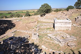
Troy was a city, both factual and legendary, in northwest Anatolia in what is now Turkey, south of the southwest end of the Dardanelles / Hellespont and northwest of Mount Ida. It is best known for being the setting of the Trojan War described in the Greek Epic Cycle and especially in the Iliad, one of the two epic poems attributed to Homer. Metrical evidence from the Iliad and the Odyssey seems to show that the name Ἴλιον (Ilion) formerly began with a digamma: Ϝίλιον (Wilion). This was later supported by the Hittite form Wilusa. A new city called Ilium was founded on the site in the reign of the Roman Emperor Augustus. It flourished until the establishment of Constantinople and declined gradually during the Byzantine era. In 1865, English archaeologist Frank Calvert excavated trial trenches in a field he had bought from a local farmer at Hisarlık, and in 1868, Heinrich Schliemann, wealthy German businessman and archaeologist, also began excavating in the area after a chance meeting with Calvert in Çanakkale. These excavations revealed several cities built in succession. Schliemann was at first skeptical about the identification of Hissarlik with Troy, but was persuaded by Calvert and took over Calvert's excavations on the eastern half of the Hissarlik site, which was on Calvert's property. Troy VII has been identified with the Hittite Wilusa, the probable origin of the Greek Ἴλιον, and is generally (but not conclusively) identified with Homeric Troy. Today, the hill at Hisarlik has given its name to a small village near the ruins, supporting the tourist trade visiting the Troia archaeological site. It lies within the province of Çanakkale, some 30 km south-west of the provincial capital, also called Çanakkale. The nearest village is Tevfikiye. The map here shows the adapted Scamander estuary with Ilium a little way inland across the Homeric plain. Troia was added to the UNESCO World Heritage list in 1998 [Wikipedia.org] |
| Data | |
| Fonte | Troy archeological site |
| Autore | Jorge Láscar from Australia |
| Luogo dello scatto | | Posizione di questa e altre immagini su: OpenStreetMap |
|---|
.jpg¶ms=039.957500_N_0026.238889_E_globe:Earth_type:camera_source:Flickr_&language=it)
Licenza
- Tu sei libero:
- di condividere – di copiare, distribuire e trasmettere quest'opera
- di modificare – di adattare l'opera
- Alle seguenti condizioni:
- attribuzione – Devi fornire i crediti appropriati, un collegamento alla licenza e indicare se sono state apportate modifiche. Puoi farlo in qualsiasi modo ragionevole, ma non in alcun modo che suggerisca che il licenziante approvi te o il tuo uso.
| Questa immagine è stata originariamente caricata su Flickr da Jorge Lascar all'indirizzo https://www.flickr.com/photos/8721758@N06/8708437345. È stata controllata in data 2 aprile 2014 dal robot FlickreviewR ed è stato confermato il suo rilascio sotto i termini della licenza cc-by-2.0. |

|
Le categorie di questa immagine andrebbero controllate. Fallo ora!
|
.jpg&action=edit&withJS=MediaWiki:Catcheck.js)
Cronologia del file
Fare clic su un gruppo data/ora per vedere il file come si presentava nel momento indicato.
| Data/Ora | Miniatura | Dimensioni | Utente | Commento | |
|---|---|---|---|---|---|
| attuale | 08:41, 2 apr 2014 | | 4 288 × 2 848 (3 MB) | Russavia | Transferred from Flickr |
Pagine che usano questo file
Le seguenti 2 pagine usano questo file:
.jpg)