File:Tanggu Truce Map.jpg
Vai alla navigazione
Vai alla ricerca

Dimensioni di questa anteprima: 794 × 600 pixel. Altre risoluzioni: 318 × 240 pixel | 635 × 480 pixel | 1 016 × 768 pixel | 1 280 × 967 pixel | 1 985 × 1 500 pixel.
File originale (1 985 × 1 500 pixel, dimensione del file: 403 KB, tipo MIME: image/jpeg)
| Questo file e la sua pagina di descrizione (discussione · modifica) si trovano su Wikimedia Commons (?) |
Dettagli
| Descrizione |
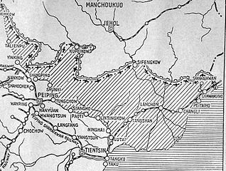
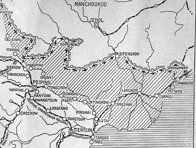
English: The shaded part of this map shows the areas demilitarized by the Tanggu Truce. Note also that the remainder of the Hebei Province, including Beijing and Tianjin, would also be demilitarized of Nationalist forces under the terms of the He-Umezu Agreement, but independent warlords like Song Zheyuan continued to operate there. |
| Data | |
| Fonte | a pamphlet called "Sino-Japanese Conflict Elucidated" |
| Autore | Canadian Japanese Association |
Licenza
This Canadian work, of which the author or authors are unknown, is in the public domain in Canada because:
(R.S.C., 2020, c. C-42, s. 6.1, R.S.C., 1993, c. C-42, s. 6.1) |
 | |
|
|
Cronologia del file
Fare clic su un gruppo data/ora per vedere il file come si presentava nel momento indicato.
| Data/Ora | Miniatura | Dimensioni | Utente | Commento | |
|---|---|---|---|---|---|
| attuale | 00:47, 19 ott 2012 | | 1 985 × 1 500 (403 KB) | CurtisNaito | User created page with UploadWizard |
Pagine che usano questo file
La seguente pagina usa questo file:
Utilizzo globale del file
Anche i seguenti wiki usano questo file:
- Usato nelle seguenti pagine di ar.wikipedia.org:
- Usato nelle seguenti pagine di en.wikipedia.org:
- Usato nelle seguenti pagine di es.wikipedia.org:
- Usato nelle seguenti pagine di fa.wikipedia.org:
- Usato nelle seguenti pagine di fr.wikipedia.org:
- Usato nelle seguenti pagine di ko.wikipedia.org:
- Usato nelle seguenti pagine di lv.wikipedia.org:
- Usato nelle seguenti pagine di nl.wikipedia.org:
- Usato nelle seguenti pagine di pt.wikipedia.org:
- Usato nelle seguenti pagine di ru.wikipedia.org:
- Usato nelle seguenti pagine di uk.wikipedia.org: