File:SundaIslands.A2003242.0225.500m.jpg
Vai alla navigazione
Vai alla ricerca

Dimensioni di questa anteprima: 776 × 600 pixel. Altre risoluzioni: 311 × 240 pixel | 621 × 480 pixel | 994 × 768 pixel | 1 280 × 989 pixel | 2 200 × 1 700 pixel.
File originale (2 200 × 1 700 pixel, dimensione del file: 600 KB, tipo MIME: image/jpeg)
| Questo file e la sua pagina di descrizione (discussione · modifica) si trovano su Wikimedia Commons (?) |
Dettagli
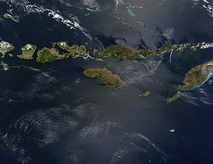
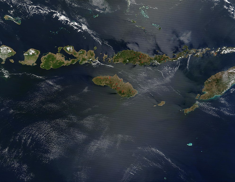
| Descrizione | The Lesser Sunda Islands, Indonesia Forming the southern arc of central Indonesia, the Lesser Sunda Islands link the island of Java (west) to the island of Timor (east). The islands stretch 1,200 kilometers west to east, and traverse the waters of the Timor, Sawu, Banda, and Flores Seas, as well as the Indian Ocean. Dotted across the islands are a number of fires, which are marked in bright red. Two tiny islands in this chain, Komodo and Rinca, are famous for being the home of dragons —of the non-mythical variety. Komodo Dragons are four-legged monitor lizards that are extremely fierce. They can weigh up to 130 kg (287 lbs) and grow to be over 3 meters (about 10 feet) in length. Komodo Dragons are a protected species, with only about 5700 of them living on these two and other smaller local islands. Komodo, Rinca, and Padar Islands (as well as numerous smaller islands) are part of Komodo National Park, which was established in 1980, and which was declared a World Heritage Site in 1991. Komodo Island is located just to the west of Flores Island, which is the long thin island dotted with numerous fires in the upper center of the image. This true-color Terra MODIS image was acquired on August 30, 2003. |
| Data | |
| Fonte | http://visibleearth.nasa.gov/view_rec.php?id=5819 |
| Autore | NASA |
| Altre versioni |
|

.jpg)
Licenza
| Questo file è nel pubblico dominio perché creato dalla NASA. La politica sul copyright della NASA afferma che «il materiale della NASA non è protetto da copyright a meno che non sia specificato altrimenti». (NASA copyright policy e JPL Image Use Policy). | ||
 |
Attenzione:
|
Cronologia del file
Fare clic su un gruppo data/ora per vedere il file come si presentava nel momento indicato.
| Data/Ora | Miniatura | Dimensioni | Utente | Commento | |
|---|---|---|---|---|---|
| attuale | 05:46, 26 ott 2005 | | 2 200 × 1 700 (600 KB) | Brian0918 | The Lesser Sunda Islands, Indonesia Forming the southern arc of central Indonesia, the Lesser Sunda Islands link the island of Java (west) to the island of Timor (east). The islands stretch 1,200 kilometers west to east, and traverse the waters of the Ti |
Pagine che usano questo file
Le seguenti 2 pagine usano questo file:
Utilizzo globale del file
Anche i seguenti wiki usano questo file:
- Usato nelle seguenti pagine di af.wikipedia.org:
- Usato nelle seguenti pagine di ar.wikipedia.org:
- Usato nelle seguenti pagine di ast.wikipedia.org:
- Usato nelle seguenti pagine di az.wikipedia.org:
- Usato nelle seguenti pagine di ba.wikipedia.org:
- Usato nelle seguenti pagine di be.wikipedia.org:
- Usato nelle seguenti pagine di bs.wikipedia.org:
- Usato nelle seguenti pagine di ca.wikipedia.org:
- Usato nelle seguenti pagine di ceb.wikipedia.org:
- Usato nelle seguenti pagine di cs.wikipedia.org:
- Usato nelle seguenti pagine di cy.wikipedia.org:
- Usato nelle seguenti pagine di da.wikipedia.org:
- Usato nelle seguenti pagine di de.wikipedia.org:
- Usato nelle seguenti pagine di el.wikipedia.org:
- Usato nelle seguenti pagine di en.wikipedia.org:
- Usato nelle seguenti pagine di eo.wikipedia.org:
- Usato nelle seguenti pagine di es.wikipedia.org:
- Usato nelle seguenti pagine di fa.wikipedia.org:
- Usato nelle seguenti pagine di fi.wikipedia.org:
- Usato nelle seguenti pagine di fi.wiktionary.org:
- Usato nelle seguenti pagine di fr.wikipedia.org:
- Usato nelle seguenti pagine di fr.wikivoyage.org:
- Usato nelle seguenti pagine di gl.wikipedia.org:
- Usato nelle seguenti pagine di he.wikipedia.org:
- Usato nelle seguenti pagine di hr.wikipedia.org:
- Usato nelle seguenti pagine di hsb.wikipedia.org:
- Usato nelle seguenti pagine di hu.wikipedia.org:
- Usato nelle seguenti pagine di id.wikipedia.org:
- Usato nelle seguenti pagine di ilo.wikipedia.org:
- Usato nelle seguenti pagine di ja.wikipedia.org:
- Usato nelle seguenti pagine di jv.wikipedia.org:
- Usato nelle seguenti pagine di ka.wikipedia.org:
- Usato nelle seguenti pagine di ko.wikipedia.org:
Visualizza l'utilizzo globale di questo file.