File:Mount Mazama eruption timeline.PNG
File originale (250 × 841 pixel, dimensione del file: 187 KB, tipo MIME: image/png)
| Questo file e la sua pagina di descrizione (discussione · modifica) si trovano su Wikimedia Commons (?) |
Dettagli
| Descrizione |
|
| Fonte | http://pubs.usgs.gov/fs/2002/fs092-02/ (saved as PNG) |
| Autore | U.S. GEOLOGICAL SURVEY and the NATIONAL PARK SERVICE |
| Altre versioni |
    |

|
Questa immagine (categorizzazione automatica: geology) o tutte le immagini in questa categoria o galleria dovrebbero essere ricreate usando grafica vettoriale come file SVG. Questo offre diversi vantaggi: vedi Commons:Media for cleanup per maggiori informazioni. Se è disponibile una versione in formato SVG di questa immagine, per favore caricala. Dopo aver caricato un file SVG, sostituisci questo avviso con il template {{Vector version available|nome_immagine.svg}}.
|
Licenza
Quest'immagine è nel pubblico dominio perché contiene materiale proveniente dallo United States Geological Survey, un'agenzia del Dipartimento degli Interni degli Stati Uniti. Per maggiori informazioni vedere la politica ufficiale dell'USGS sul copyright.
|
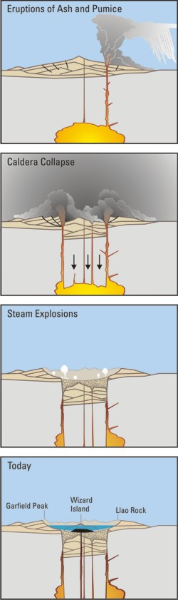
Crater Lake is an example, it is located in Oregen and was made from a valcano, making a caldera.
Cronologia del file
Fare clic su un gruppo data/ora per vedere il file come si presentava nel momento indicato.
| Data/Ora | Miniatura | Dimensioni | Utente | Commento | |
|---|---|---|---|---|---|
| attuale | 07:24, 29 mar 2006 | 250 × 841 (187 KB) | Jkelly | Source: http://pubs.usgs.gov/fs/2002/fs092-02/ (saved as PNG) Author: U.S. GEOLOGICAL SURVEY and the NATIONAL PARK SERVICE Description: <blockquote>Cataclysmic eruption to present. Eruptions of ash and pumice: The cataclysmic eruption started from a ve |
Pagine che usano questo file
Le seguenti 3 pagine usano questo file:
Utilizzo globale del file
Anche i seguenti wiki usano questo file:
- Usato nelle seguenti pagine di af.wikipedia.org:
- Usato nelle seguenti pagine di an.wikipedia.org:
- Usato nelle seguenti pagine di ar.wikipedia.org:
- Usato nelle seguenti pagine di ast.wikipedia.org:
- Usato nelle seguenti pagine di br.wikipedia.org:
- Usato nelle seguenti pagine di ce.wikipedia.org:
- Usato nelle seguenti pagine di cy.wikipedia.org:
- Usato nelle seguenti pagine di de.wikipedia.org:
- Usato nelle seguenti pagine di en.wikipedia.org:
- Usato nelle seguenti pagine di en.wikiversity.org:
- Usato nelle seguenti pagine di eo.wikipedia.org:
- Usato nelle seguenti pagine di es.wikipedia.org:
- Usato nelle seguenti pagine di fa.wikipedia.org:
- Usato nelle seguenti pagine di fi.wikipedia.org:
- Usato nelle seguenti pagine di fr.wikipedia.org:
- Usato nelle seguenti pagine di id.wikipedia.org:
- Usato nelle seguenti pagine di ja.wikipedia.org:
- Usato nelle seguenti pagine di ko.wikipedia.org:
- Usato nelle seguenti pagine di lv.wikipedia.org:
- Usato nelle seguenti pagine di min.wikipedia.org:
- Usato nelle seguenti pagine di mk.wikipedia.org:
- Usato nelle seguenti pagine di ml.wikipedia.org:
- Usato nelle seguenti pagine di pt.wikipedia.org:
- Usato nelle seguenti pagine di ru.wikipedia.org:
- Usato nelle seguenti pagine di simple.wikipedia.org:
- Usato nelle seguenti pagine di sk.wikipedia.org:
- Usato nelle seguenti pagine di sr.wikipedia.org:
- Usato nelle seguenti pagine di su.wikipedia.org:
- Usato nelle seguenti pagine di vi.wikipedia.org:
- Usato nelle seguenti pagine di www.wikidata.org: