File:Fonseca gulf.jpg
Vai alla navigazione
Vai alla ricerca

Dimensioni di questa anteprima: 615 × 600 pixel. Altre risoluzioni: 246 × 240 pixel | 492 × 480 pixel | 640 × 624 pixel.
File originale (640 × 624 pixel, dimensione del file: 109 KB, tipo MIME: image/jpeg)
| Questo file e la sua pagina di descrizione (discussione · modifica) si trovano su Wikimedia Commons (?) |
Dettagli
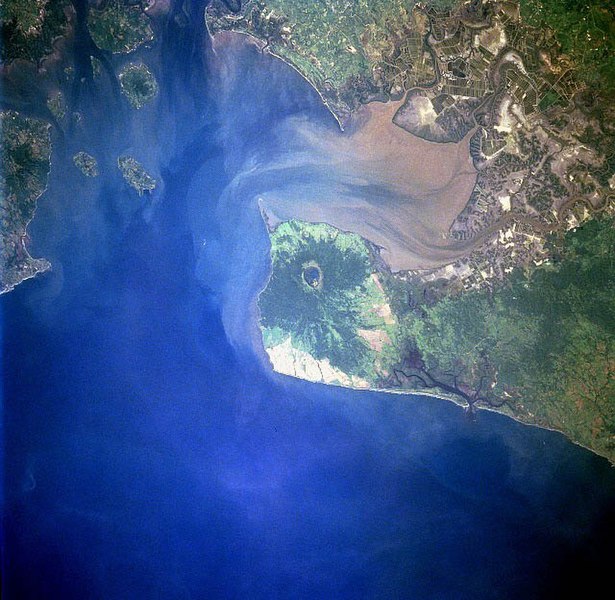
| Descrizione |
Gulf of Fonseca, El Salvador, Honduras, Nicaragua |
| Data | |
| Fonte | eol.jsc.nasa.gov |
| Autore | NASA |
| Altre versioni |
.jpg)
Licenza
| Questo file è nel pubblico dominio perché creato dalla NASA. La politica sul copyright della NASA afferma che «il materiale della NASA non è protetto da copyright a meno che non sia specificato altrimenti». (NASA copyright policy e JPL Image Use Policy). | ||
 |
Attenzione:
|
Cronologia del file
Fare clic su un gruppo data/ora per vedere il file come si presentava nel momento indicato.
| Data/Ora | Miniatura | Dimensioni | Utente | Commento | |
|---|---|---|---|---|---|
| attuale | 11:40, 22 nov 2022 | | 640 × 624 (109 KB) | SteinsplitterBot | Bot: Image rotated by 270° |
| 06:10, 10 dic 2005 |  | 631 × 640 (110 KB) | Thuresson | Gulf of Fonseca, El Salvador, Honduras, Nicaragua - July 1997 *Image courtesy of the Image Science & Analysis Laboratory, NASA Johnson Space Center. *Source: [http://eol.jsc.nasa.gov/sseop/EFS/photoinfo.pl?PHOTO=STS094-723-83 eol.jsc.nasa.gov] *Photo #: |
Pagine che usano questo file
Le seguenti 2 pagine usano questo file:
Utilizzo globale del file
Anche i seguenti wiki usano questo file:
- Usato nelle seguenti pagine di de.wikipedia.org:
- Usato nelle seguenti pagine di el.wikipedia.org:
- Usato nelle seguenti pagine di en.wikipedia.org:
- Usato nelle seguenti pagine di eo.wikipedia.org:
- Usato nelle seguenti pagine di es.wikipedia.org:
- Usato nelle seguenti pagine di fr.wikipedia.org:
- Usato nelle seguenti pagine di gl.wikipedia.org:
- Usato nelle seguenti pagine di ja.wikipedia.org:
- Usato nelle seguenti pagine di lt.wikipedia.org:
- Usato nelle seguenti pagine di nl.wikipedia.org:
- Usato nelle seguenti pagine di pl.wikipedia.org:
- Usato nelle seguenti pagine di pt.wikipedia.org:
- Usato nelle seguenti pagine di ru.wikipedia.org:
- Usato nelle seguenti pagine di sk.wikipedia.org:
- Usato nelle seguenti pagine di uk.wikipedia.org:
- Usato nelle seguenti pagine di www.wikidata.org: