File:De facto cantons of Rojava.png
Vai alla navigazione
Vai alla ricerca

Dimensioni di questa anteprima: 725 × 599 pixel. Altre risoluzioni: 290 × 240 pixel | 581 × 480 pixel | 929 × 768 pixel | 1 239 × 1 024 pixel | 2 000 × 1 653 pixel.
File originale (2 000 × 1 653 pixel, dimensione del file: 268 KB, tipo MIME: image/png)
| Questo file e la sua pagina di descrizione (discussione · modifica) si trovano su Wikimedia Commons (?) |

|
Questa immagine (categorizzazione automatica: map) o tutte le immagini in questa categoria o galleria dovrebbero essere ricreate usando grafica vettoriale come file SVG. Questo offre diversi vantaggi: vedi Commons:Media for cleanup per maggiori informazioni. Se è disponibile una versione in formato SVG di questa immagine, per favore caricala. Dopo aver caricato un file SVG, sostituisci questo avviso con il template {{Vector version available|nome_immagine.svg}}.
|
Dettagli
| Descrizione |
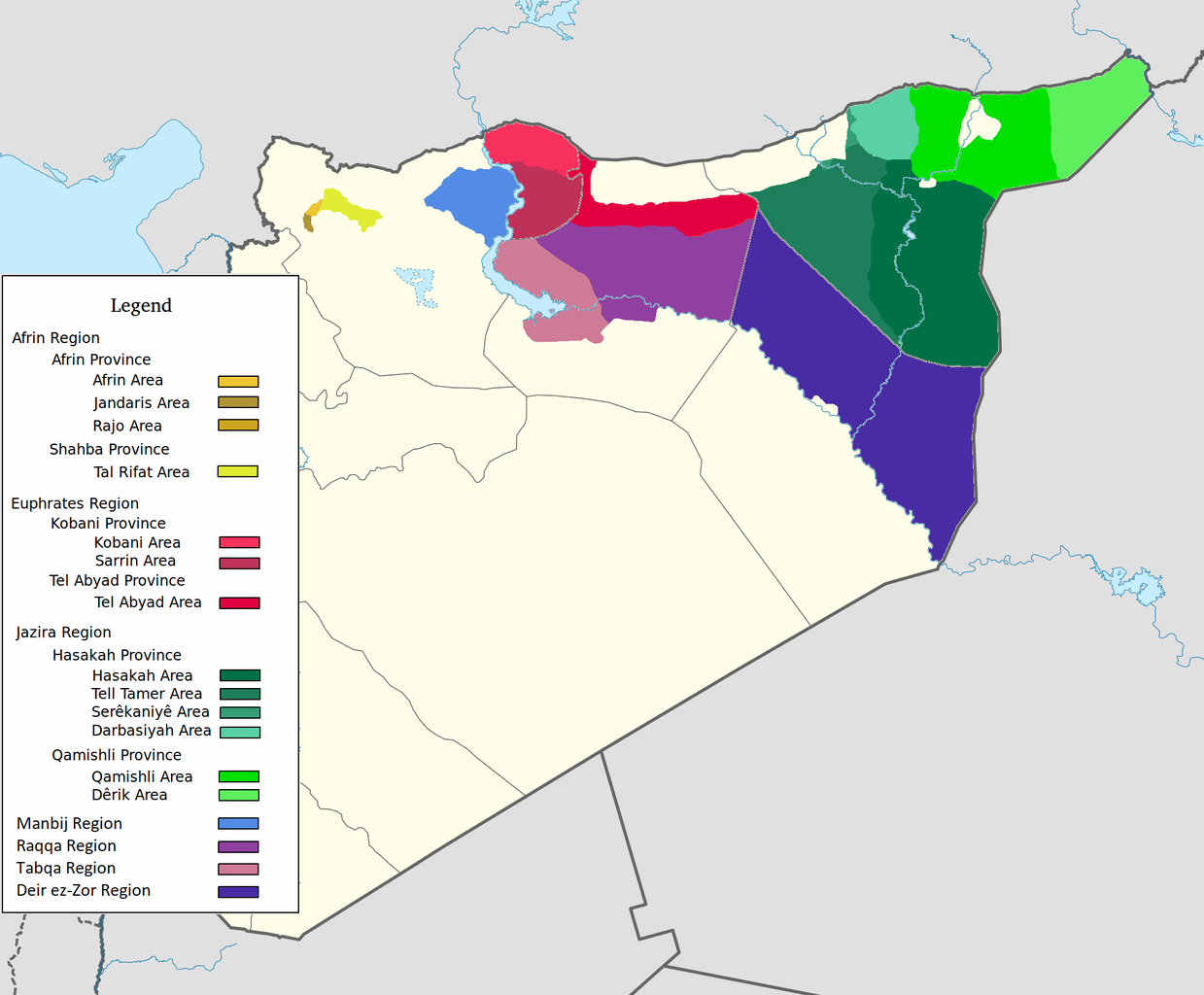
العربية: اقليم عفرين اقليم الفرات اقليم الجزيرة English: Afrin Region Euphrates Region Jazeera Region No region 한국어: 아프린 주 유프라테스 주 자제라 주 없음 |
| Data | |
| Fonte | Opera propria |
| Autore | Editor abcdef |
| Altre versioni |
Questa immagine include elementi che sono stati presi o adattati da questa:  |
Licenza
Io, detentore del copyright su quest'opera, dichiaro di pubblicarla con la seguente licenza:
Questo file è disponibile in base alla licenza Creative Commons Attribuzione-Condividi allo stesso modo 3.0 Unported
- Tu sei libero:
- di condividere – di copiare, distribuire e trasmettere quest'opera
- di modificare – di adattare l'opera
- Alle seguenti condizioni:
- attribuzione – Devi fornire i crediti appropriati, un collegamento alla licenza e indicare se sono state apportate modifiche. Puoi farlo in qualsiasi modo ragionevole, ma non in alcun modo che suggerisca che il licenziante approvi te o il tuo uso.
- condividi allo stesso modo – Se remixi, trasformi o sviluppi il materiale, devi distribuire i tuoi contributi in base alla stessa licenza o compatibile all'originale.
Cronologia del file
Fare clic su un gruppo data/ora per vedere il file come si presentava nel momento indicato.
| Data/Ora | Miniatura | Dimensioni | Utente | Commento | |
|---|---|---|---|---|---|
| attuale | 10:29, 27 mag 2020 | | 2 000 × 1 653 (268 KB) | AntonSamuel | Reverted to version as of 09:02, 8 April 2020 (UTC) Restoring original map without stripes per COM:OW and discussion on the Rojava talk page on Wikipedia |
| 11:05, 8 apr 2020 |  | 2 000 × 1 653 (224 KB) | Bill497 | Reverted to version as of 08:59, 8 April 2020 (UTC) Revert vandalism. | |
| 11:02, 8 apr 2020 |  | 2 000 × 1 653 (268 KB) | AntonSamuel | Reverted to version as of 08:51, 8 April 2020 (UTC) Third, and last warning given on user talk page. | |
| 10:59, 8 apr 2020 |  | 2 000 × 1 653 (224 KB) | Bill497 | Reverted to version as of 08:11, 8 April 2020 (UTC) Revert vandalism for a 3rd time. User is reverting a referenced map to an unreferenced version. | |
| 10:51, 8 apr 2020 |  | 2 000 × 1 653 (268 KB) | AntonSamuel | Reverted to version as of 17:57, 7 April 2020 (UTC) Once again, use the Rojava talk page to discuss before making reverts and don't throw around unfounded vandalism claims. Second warning on talk page given. | |
| 10:11, 8 apr 2020 |  | 2 000 × 1 653 (224 KB) | Bill497 | Reverted to version as of 11:10, 7 April 2020 (UTC) Revert vandalism. | |
| 19:57, 7 apr 2020 |  | 2 000 × 1 653 (268 KB) | AntonSamuel | Reverted to version as of 00:50, 7 April 2020 (UTC) Restoring viewable version - Use Rojava talk page, warning left on user talk page | |
| 13:10, 7 apr 2020 |  | 2 000 × 1 653 (224 KB) | Bill497 | Reverted to version as of 12:33, 2 April 2020 (UTC) Revert attempted vandalism into a factually incorrect version of the map. SDF has entirely no presence in some of the dashed zones. Due to fog of war these areas are all displaced as mixed with government control. Russia is the only reliable source displaying where the government is present. | |
| 02:50, 7 apr 2020 |  | 2 000 × 1 653 (268 KB) | AntonSamuel | Continuation from below: ...manner. Further sources are needed apart from the Russian military maps - they cannot be considered to be neutral or factually accurate without additional verification. | |
| 02:46, 7 apr 2020 |  | 2 000 × 1 653 (218 KB) | AntonSamuel | Clearing the 50/50 paint because of the visual difficulty and for deviation from the main purpose of this map - which is to display the various subregions of the civilian administration of the de facto autonomous region, not military control agreements such as SDF-SAA/Russia and SDF-US/US-led coalition which have no known civilian aspect as of date. Please discuss the issue first and foremost on the Rojava talk page if areas with an SAA/Russian or a US presence need to be highlighted in some... |
Pagine che usano questo file
Nessuna pagina utilizza questo file.
Utilizzo globale del file
Anche i seguenti wiki usano questo file:
- Usato nelle seguenti pagine di ar.wikipedia.org:
- Usato nelle seguenti pagine di arz.wikipedia.org:
- Usato nelle seguenti pagine di azb.wikipedia.org:
- Usato nelle seguenti pagine di ca.wikipedia.org:
- Usato nelle seguenti pagine di diq.wikipedia.org:
- Usato nelle seguenti pagine di fa.wikipedia.org:
- Usato nelle seguenti pagine di glk.wikipedia.org:
- Usato nelle seguenti pagine di id.wikipedia.org:
- Usato nelle seguenti pagine di ku.wikipedia.org:
- Usato nelle seguenti pagine di nl.wikipedia.org:
- Usato nelle seguenti pagine di ru.wikipedia.org:
- Usato nelle seguenti pagine di tr.wikipedia.org:
- Usato nelle seguenti pagine di vi.wikipedia.org:
- Usato nelle seguenti pagine di www.wikidata.org:
- Usato nelle seguenti pagine di zh.wikipedia.org: