File:Cornelis anthonisz vogelvluchtkaart amsterdam.JPG
Vai alla navigazione
Vai alla ricerca
Dimensioni di questa anteprima: 616 × 599 pixel. Altre risoluzioni: 247 × 240 pixel | 493 × 480 pixel | 789 × 768 pixel | 1 052 × 1 024 pixel | 2 231 × 2 171 pixel.
File originale (2 231 × 2 171 pixel, dimensione del file: 1,7 MB, tipo MIME: image/jpeg)
| Questo file e la sua pagina di descrizione (discussione · modifica) si trovano su Wikimedia Commons (?) |
Dettagli
| Cornelis Anthonisz: Q116787851
|
|||||||||||||||||||||||||||||||||||||||||||||||
|---|---|---|---|---|---|---|---|---|---|---|---|---|---|---|---|---|---|---|---|---|---|---|---|---|---|---|---|---|---|---|---|---|---|---|---|---|---|---|---|---|---|---|---|---|---|---|---|
| Artista |
|
 | |||||||||||||||||||||||||||||||||||||||||||||
| Titolo |
tedesco: Die berühmte Handelsstadt Amsterdam
olandese: De vermaerde koopstadt van Amstelredam
|
||||||||||||||||||||||||||||||||||||||||||||||
| Tipo di oggetto | stampa | ||||||||||||||||||||||||||||||||||||||||||||||
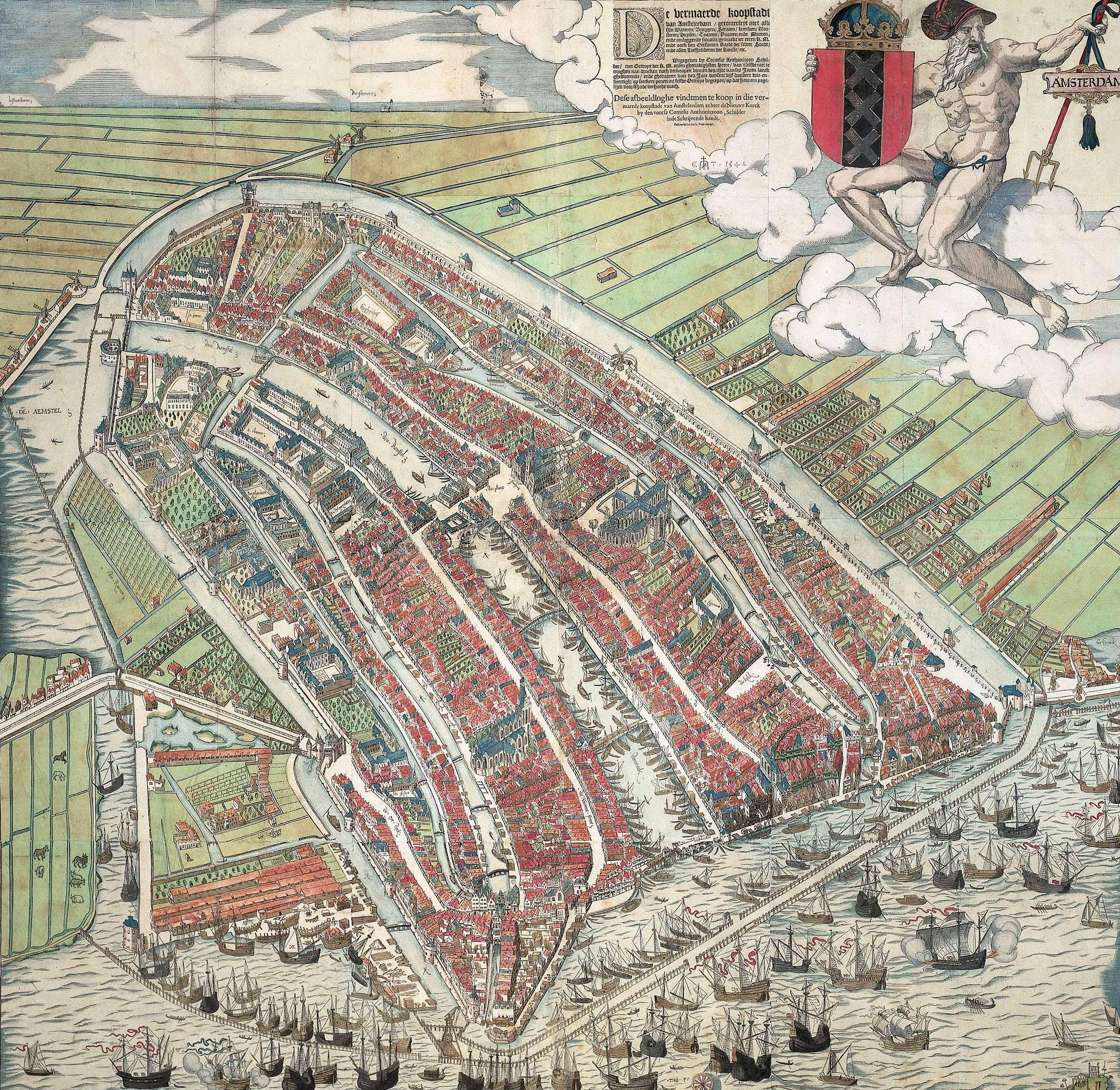
| Descrizione |
A bird's eye view of Amsterdam looking south. This is the city before the construction of the semi-circular ring of canals. It is bordered by the IJ, the Singel in the west, and the Kloveniersburgwal/Gelderse Kade in the east. The waterway in the middle (connecting the Dam with the IJ) is known as the Damrak. Ships were unloaded on the west bank of the Damrak, indicated on the map as ‘Opt Waeter’ (on the water). Woodcut by Cornelis Anthonisz. dated 1544. Fourth edition out of a total of six editions. This version is a reprint published by Ian Iansz. around 1557. |
||||||||||||||||||||||||||||||||||||||||||||||
| Data | 1557 circa | ||||||||||||||||||||||||||||||||||||||||||||||
| Tecnica/materiale | xilografia, pennello e colore | ||||||||||||||||||||||||||||||||||||||||||||||
| Dimensioni | altezza: 107 cm; larghezza: 109 cm | ||||||||||||||||||||||||||||||||||||||||||||||
| Collezione |
|
||||||||||||||||||||||||||||||||||||||||||||||
| Numero d'inventario |
KOG-2684 (Royal Dutch Antiquarian Society) |
||||||||||||||||||||||||||||||||||||||||||||||
| Luogo di creazione | Amsterdam | ||||||||||||||||||||||||||||||||||||||||||||||
| Provenienza |
Data sconosciuta: acquisito da Koninklijk Oudheidkundig Genootschap, Numero di inventario KOG-2684, da jkvr. H.M.A.F. Six (?) Data sconosciuta: prestato a the Rijksmuseum Amsterdam, Amsterdam, da Koninklijk Oudheidkundig Genootschap (?) |
||||||||||||||||||||||||||||||||||||||||||||||
| Esposizioni | Het Aanzien van Amsterdam. Panorama's, plattegronden en profielen uit de Gouden Eeuw, Archivio municipale di Amsterdam, Amsterdam, 19 ottobre 2007–16 gennaio 2008, ISBN 978-90-6868-444-5, p. 90-92, cat. nº 4, with color image, come Plattegrond van Amsterdam met de gebouwen in opstand, Amsterdam, Koninklijk Oudheidkundig Genootschap. | ||||||||||||||||||||||||||||||||||||||||||||||
| Iscrizioni |
Legenda in alto a destra: De vermaerde koopstadt / van Amstelredam, gheconterfeyt met alle / sijn Wateren, Bruggen, Straten, kercken, kloo- / steren, Huysen, Toorens, Poorten ende Mueren, / ende omleggende situatie, gemaekt ter eeren K. M. / ende oock den Eersamen Raedt der selver Stadt, / ende alle Liefhebberen der Konste, etc. // Wtgegeven by Cornelis Anthonizoon Schil- / der, met Octroye der K. M. onsen ghenadighsten Heere van 't selfde niet te / moghen nae-drucken noch verkoopen binnen den tijdt van ses Jaren lanck / gheduerende, ende ghedateert van den Jare duysent vijf-honderd drie-en- / veertigh, op seeckere penen int selvde Octroye begrepen, op dat hem een yege- / lijck voor schade verhoede mach. // Dese afbeeldinghe vindtmen te koop in die ver- / maerde koopstadt van Amstelredam achter de Nieuwe Kerck / by den voorsz Cornelis Anthoniszoon, Schilder / inde Schrijvende handt. // ende nu by Ian Iansz, Print-drucker |
||||||||||||||||||||||||||||||||||||||||||||||
| Note | Van deze plattegrond zijn zes verschillende uitgaves bekend; uit 1544, 1544-1545, 1545-1553, ca. 1557, ca. 1557-1636 en 1636-1664. | ||||||||||||||||||||||||||||||||||||||||||||||
| Riferimenti | |||||||||||||||||||||||||||||||||||||||||||||||
| Fonte/Fotografo | archive.org, cultuurwijzer.nl/nwc.gemeentearchiefamsterdam | ||||||||||||||||||||||||||||||||||||||||||||||
| Altre versioni |
|
||||||||||||||||||||||||||||||||||||||||||||||
.jpg)


_by_Cornelis_Anthonisz.jpg)
| Annotazioni | Questa immagine è annotata: Vedi le annotazioni su Commons |


Licenza
|
Questa è una fedele riproduzione fotografica di un'opera d'arte bidimensionale originale. L'opera d'arte fotografata è nel pubblico dominio per la seguente ragione:
La posizione ufficiale presa dalla Wikimedia Foundation è che le riproduzioni fedeli di opere d'arte bidimensionali nel pubblico dominio siano da considerare anch'esse nel pubblico dominio, e che qualsiasi affermazione contraria rappresenta un attacco al concetto stesso di pubblico dominio ("faithful reproductions of two-dimensional public domain works of art are public domain, and that claims to the contrary represent an assault on the very concept of a public domain"). Per maggiori dettagli, vedi Commons:When to use the PD-Art tag.
Questa riproduzione fotografica è di conseguenza da considerarsi nel pubblico dominio. Per favore, fai attenzione al fatto che, a seconda delle leggi locali, il riutilizzo di questo contenuto potrebbe essere proibito o limitato nella tua giurisdizione. Vedi Commons:Reuse of PD-Art photographs. | ||||
Cronologia del file
Fare clic su un gruppo data/ora per vedere il file come si presentava nel momento indicato.
| Data/Ora | Miniatura | Dimensioni | Utente | Commento | |
|---|---|---|---|---|---|
| attuale | 13:05, 11 apr 2008 | | 2 231 × 2 171 (1,7 MB) | Vincent Steenberg | {{Information |Description={{en|Cornelis Anthonisz. ''Bird's eye view of Amsterdam.'' 1544. Woodcut.}} {{nl|Cornelis Anthonisz. ''Vogelvluchtkaart van Amsterdam.'' 1544. Houtsnede.}} |Source=http://www.cultuurwijzer.nl/nwc.gemeentearchiefamsterdam/cultuur |
Pagine che usano questo file
Nessuna pagina utilizza questo file.
Utilizzo globale del file
Anche i seguenti wiki usano questo file:
- Usato nelle seguenti pagine di ar.wikipedia.org:
- Usato nelle seguenti pagine di en.wikipedia.org:
- Usato nelle seguenti pagine di hy.wikipedia.org:
- Usato nelle seguenti pagine di nl.wikipedia.org:
- Usato nelle seguenti pagine di vi.wikipedia.org:
- Usato nelle seguenti pagine di www.wikidata.org:
- Usato nelle seguenti pagine di zh.wikipedia.org: