File:Battle of Wauhatchie map.jpg

File originale (2 082 × 2 214 pixel, dimensione del file: 2,77 MB, tipo MIME: image/jpeg)
| Questo file e la sua pagina di descrizione (discussione · modifica) si trovano su Wikimedia Commons (?) |
Dettagli
| Descrizione |
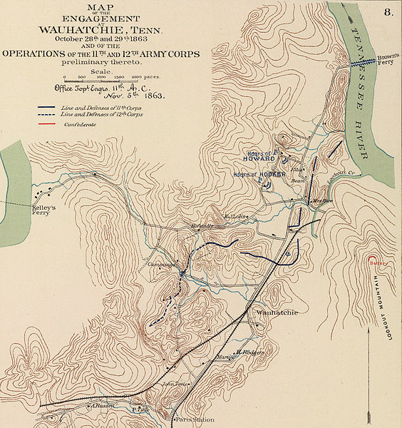
English: Author: Morris, Walter J.; United States. War Department
Date: 1895 Short Title: Army of Missouri campaigns. Publisher: Washington: U.S. Government Printing Office Type: Atlas Map Obj Height cm: 43 Obj Width cm: 70 Scale 1: 2,217,600 Note: Col. map with 7 ancillary maps. Relief in some ancillary maps shown by hachures or form lines. State/Province: Missouri ; Arkansas ; Oklahoma ; Georgia County: Walker County (Ga.) ; Spotsylvania County (Va.) Event: U.S. Civil War Subject: Military Full Title: Map of the fall campaigns of the Army of Missouri, Maj. Gen. Sterling Price, commanding in Sept., Oct., Nov. 1864. Capt. T.J. Mackey, Chf. Engr. (with) No. 2. Map of the battle of Chickamauga showing the positions of the Confederate and Federal armies on the 19th September, 1863 ... by Walter J. Morris ... (with) No. 3. Map of the battle of Chickamauga ... 19th September 1863 ... by Walter J. Morris ... (with Marietta Region, Georgia). Accompanying letter of Maj. Gen. J.M. Scholfield ... (with Peach Tree Creek Region, Georgia) Marked "Thomas" by Gen. Sherman. (with) Mine Run, Va. and vicinity, 1863. (with) No. 1. Map showing the positions of the Confederate Army and that of the Federal Army at midnight on the 18th of September, 1863, the night previous to the general engagements of the 19th and 20th Sept., or the Battle of Chickamauga ... by Walter J. Morris ... (with) Map of the engagement at Wauhatchie, Tenn., October 28th and 29th, 1863 and of the operations of the 11th and 12th Army Corps preliminary thereto. To accompany report of Maj. Gen. Joseph Hooker. Julius Bien & Co., Lith., N.Y. (1891-1895) Engraver or Printer: Julius Bien & Co. ; Price, Sterling ; Mackey, Thomas J. ; Schofield, John M. ; Thomas, George H. ; Sherman, William T. ; Hooker, Joseph Publication Author: United States. War Department; Davis, George B.; Perry, Leslie J.; Kirkley, JAW.; Cowles, Calvin D. Pub Date: 1895 Pub Title: Atlas to accompany the official records of the Union and Confederate armies. Published under the direction of the Hons. Redfield Proctor, Stephen B. Elkins and Daniel S. Lamont, secretaries of war, by Maj. George B. Davis, U.S. Army, Mr. Leslie J. Perry, civilian expert, Mr. Joseph W. Kirkley, civilian expert, Board of Publication. Compiled by Capt. Calvin D. Cowles, 23d U.S. Infantry. Washington: Government Printing Office, 1891-1895. Pub Reference: LC Civil War maps (2nd ed.), 99; Civil War maps in the National Archives, 8; Phillips, 1353; LeGear. Atlases of the United States, 266. http://www.davidrumsey.com/rumsey/download.pl?image=/D0110/1780047.sid (need MrSid viewer) |
| Fonte | Sconosciuta |
| Autore | Sconosciuto |
Licenza
|
Questa è una fedele riproduzione fotografica di un'opera d'arte bidimensionale originale. L'opera d'arte fotografata è nel pubblico dominio per la seguente ragione:
La posizione ufficiale presa dalla Wikimedia Foundation è che le riproduzioni fedeli di opere d'arte bidimensionali nel pubblico dominio siano da considerare anch'esse nel pubblico dominio, e che qualsiasi affermazione contraria rappresenta un attacco al concetto stesso di pubblico dominio ("faithful reproductions of two-dimensional public domain works of art are public domain, and that claims to the contrary represent an assault on the very concept of a public domain"). Per maggiori dettagli, vedi Commons:When to use the PD-Art tag.
Questa riproduzione fotografica è di conseguenza da considerarsi nel pubblico dominio. Per favore, fai attenzione al fatto che, a seconda delle leggi locali, il riutilizzo di questo contenuto potrebbe essere proibito o limitato nella tua giurisdizione. Vedi Commons:Reuse of PD-Art photographs. |


Registro originale del caricamento
| Data/Ora | Dimensioni | Utente | Commento |
|---|---|---|---|
| 2005-04-07 12:12 | 2082×2214× (2900377 bytes) | Brian0918 | Author: Morris, Walter J.; United States. War Department Date: 1895 Short Title: Army of Missouri campaigns. Publisher: Washington: U.S. Government Printing Office Type: Atlas Map Obj Height cm: 43 Obj Width cm: 70 Scale 1: 2,217,600 Note: C |
Cronologia del file
Fare clic su un gruppo data/ora per vedere il file come si presentava nel momento indicato.
| Data/Ora | Miniatura | Dimensioni | Utente | Commento | |
|---|---|---|---|---|---|
| attuale | 10:00, 3 apr 2016 | | 2 082 × 2 214 (2,77 MB) | Tikky19 | Transferred from en.wikipedia |
Pagine che usano questo file
La seguente pagina usa questo file:
Utilizzo globale del file
Anche i seguenti wiki usano questo file:
- Usato nelle seguenti pagine di en.wikipedia.org:
- Usato nelle seguenti pagine di en.wikivoyage.org:
- Usato nelle seguenti pagine di fr.wikipedia.org:
- Usato nelle seguenti pagine di ru.wikipedia.org:
- Usato nelle seguenti pagine di www.wikidata.org: