File:Penang.gif
File originale (461 × 604 pixel, dimensione del file: 18 KB, tipo MIME: image/gif, ciclico, 7 frame, 11 s)
| Questo file e la sua pagina di descrizione (discussione · modifica) si trovano su Wikimedia Commons (?) |
Dettagli
| Descrizione |
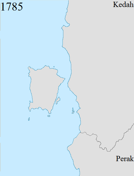
English: Territorial changes of the former British crown colony of Penang, now a state in Malaysia. Penang's present-day boundaries date back to 1874, when the final change to the boundaries was made following the Pangkor Treaty between the British Empire and Perak.
1786: The British East India Company acquired Penang Island from Kedah. 1800: The British East India Company acquired Province Wellesley from Kedah. At the time, Province Wellesley encompassed a thin strip of land south of the Perai River. 1831: The British East India Company expanded Province Wellesley northwards following a treaty with Siam, which had by then annexed Kedah.[1][2] Province Wellesley now included an area between the Muda River to the north and the Perai River to the south, with the Muda River serving as the boundary between Province Wellesley and Siam. 1859: The British East India Company and Siam signed another treaty to demarcate Province Wellesley's eastern boundaries with Siam.[3] 1874: Province Wellesley was expanded to include the southern watershed of the Kerian River, following the Pangkor Treaty between the British Empire and Perak.[4] Penang's boundaries have remained unchanged since then. |
| Data | |
| Fonte | Opera propria |
| Autore | Dreamtrooper |
Licenza
- Tu sei libero:
- di condividere – di copiare, distribuire e trasmettere quest'opera
- di modificare – di adattare l'opera
- Alle seguenti condizioni:
- attribuzione – Devi fornire i crediti appropriati, un collegamento alla licenza e indicare se sono state apportate modifiche. Puoi farlo in qualsiasi modo ragionevole, ma non in alcun modo che suggerisca che il licenziante approvi te o il tuo uso.
- condividi allo stesso modo – Se remixi, trasformi o sviluppi il materiale, devi distribuire i tuoi contributi in base alla stessa licenza o compatibile all'originale.
- ↑ Plan Of Prince Of Wales Island And Province Wellesley. www.nas.gov.sg. Retrieved on 2017-09-02.
- ↑ Map of Prince of Wales Island, or Pulo Penang and Province …. www.nas.gov.sg. Retrieved on 2017-09-02.
- ↑ Map Of Prince Of Wales Island And Province Wellesley, …. www.nas.gov.sg. Retrieved on 2017-09-02.
- ↑ Documents Archive | Empire in Asia (in en). www.fas.nus.edu.sg. Retrieved on 2017-05-01.
Cronologia del file
Fare clic su un gruppo data/ora per vedere il file come si presentava nel momento indicato.
| Data/Ora | Miniatura | Dimensioni | Utente | Commento | |
|---|---|---|---|---|---|
| attuale | 11:49, 2 set 2017 | | 461 × 604 (18 KB) | Vnonymous | User created page with UploadWizard |
Pagine che usano questo file
La seguente pagina usa questo file:
Utilizzo globale del file
Anche i seguenti wiki usano questo file:
- Usato nelle seguenti pagine di en.wikipedia.org:
- Usato nelle seguenti pagine di ms.wikipedia.org:
- Usato nelle seguenti pagine di sr.wikipedia.org: