File:NUTS 3 regions of Scotland map.svg
Vai alla navigazione
Vai alla ricerca

Dimensioni di questa anteprima PNG per questo file SVG: 456 × 600 pixel. Altre risoluzioni: 182 × 240 pixel | 365 × 480 pixel | 584 × 768 pixel | 779 × 1 024 pixel | 1 558 × 2 048 pixel | 1 023 × 1 345 pixel.
File originale (file in formato SVG, dimensioni nominali 1 023 × 1 345 pixel, dimensione del file: 2,92 MB)
| Questo file e la sua pagina di descrizione (discussione · modifica) si trovano su Wikimedia Commons (?) |
Dettagli
| Descrizione | |
| Data | (UTC) |
| Fonte |
Questo file deriva da: |
| Autore |
|
| Altre versioni | File:NUTS 3 regions of central and southern Scotland map.svg shows an enlargement of the southern part of this map. |


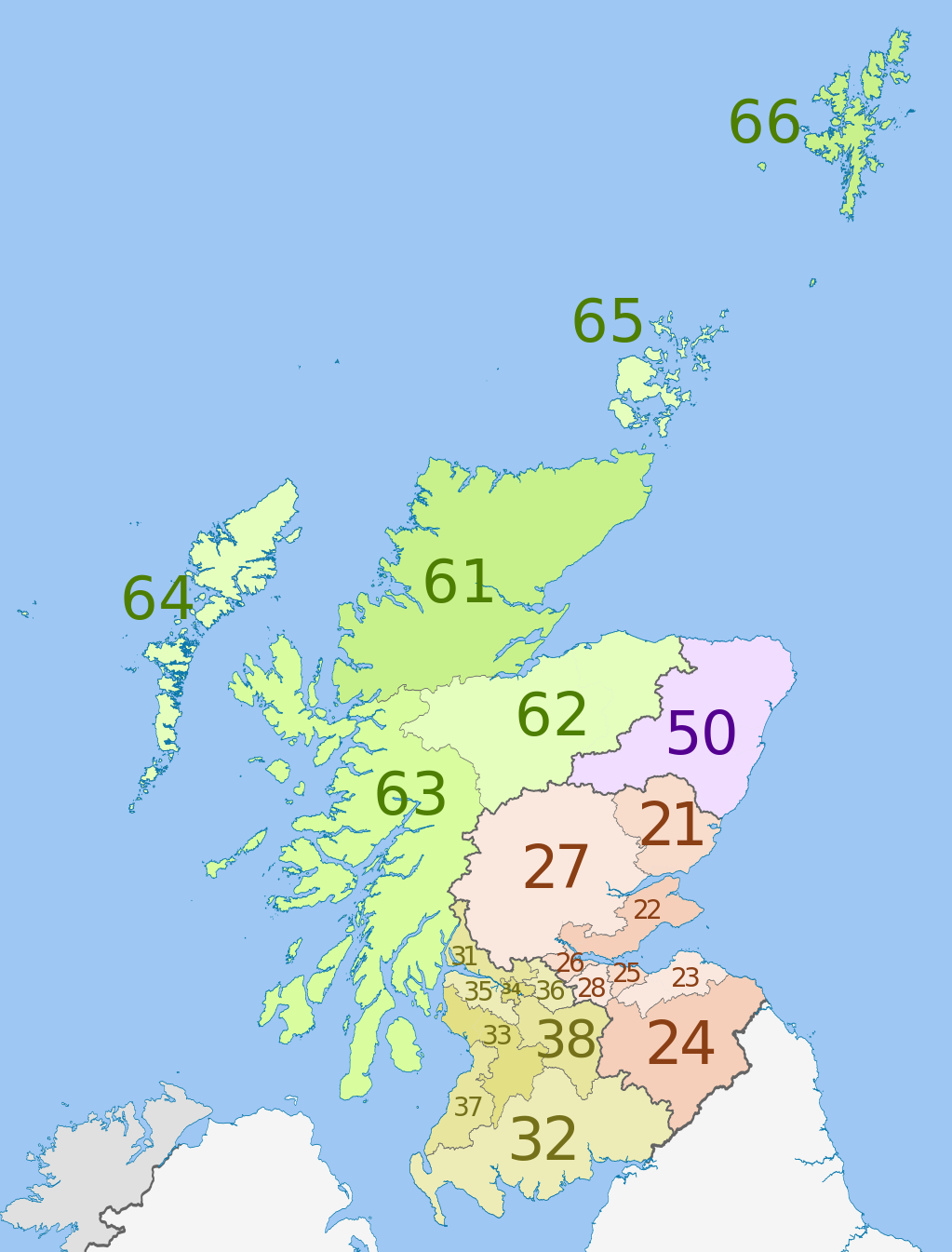
| NUTS 1 | Code | NUTS 2 | Code | NUTS 3 | Code |
|---|---|---|---|---|---|
| Scotland | UKM | Eastern Scotland | UKM2 | Angus and Dundee | UKM21 |
| Clackmannanshire and Fife | UKM22 | ||||
| East Lothian and Midlothian | UKM23 | ||||
| Scottish Borders | UKM24 | ||||
| Edinburgh | UKM25 | ||||
| Falkirk | UKM26 | ||||
| Perth and Kinross, and Stirling | UKM27 | ||||
| West Lothian | UKM28 | ||||
| South Western Scotland | UKM3 | East Dunbartonshire, West Dunbartonshire, and Helensburgh and Lomond | UKM31 | ||
| Dumfries and Galloway | UKM32 | ||||
| East and North Ayrshire mainland | UKM33 | ||||
| Glasgow | UKM34 | ||||
| Inverclyde, East Renfrewshire, and Renfrewshire | UKM35 | ||||
| North Lanarkshire | UKM36 | ||||
| South Ayrshire | UKM37 | ||||
| South Lanarkshire | UKM38 | ||||
| North Eastern Scotland | UKM5 | Aberdeen and Aberdeenshire | UKM50 | ||
| Highlands and Islands | UKM6 | Caithness and Sutherland, and Ross and Cromarty | UKM61 | ||
| Inverness, Nairn, Moray, and Badenoch and Strathspey | UKM62 | ||||
| Lochaber, Skye and Lochalsh, Arran and Cumbrae, and Argyll and Bute (except Helensburgh and Lomond) | UKM63 | ||||
| Eilean Siar (Western Isles) | UKM64 | ||||
| Orkney Islands | UKM65 | ||||
| Shetland Islands | UKM66 |
Licenza
Questo file è disponibile in base alla licenza Creative Commons Attribuzione-Condividi allo stesso modo 3.0 Unported
Attribuzione: Dr Greg, Nilfanion & XrysD. Contains Ordnance Survey data © Crown copyright and database right 2011
- Tu sei libero:
- di condividere – di copiare, distribuire e trasmettere quest'opera
- di modificare – di adattare l'opera
- Alle seguenti condizioni:
- attribuzione – Devi fornire i crediti appropriati, un collegamento alla licenza e indicare se sono state apportate modifiche. Puoi farlo in qualsiasi modo ragionevole, ma non in alcun modo che suggerisca che il licenziante approvi te o il tuo uso.
- condividi allo stesso modo – Se remixi, trasformi o sviluppi il materiale, devi distribuire i tuoi contributi in base alla stessa licenza o compatibile all'originale.
Registro originale del caricamento
This image is a derivative work of the following images:
- File:Scottish_council_areas_2011.svg licensed with Cc-by-sa-3.0
- 2011-05-01T19:21:40Z Nilfanion 1023x1345 (3008417 Bytes) {{Information |Description=Map showing the [[w:Council areas of Scotland|Council areas of Scotland]] in 2011. Equirectangular map projection on WGS 84 datum, with N/S stretched 170% Geographic limits: *West: 8.8W *East: 0.4
- File:Scotland_Administrative_Map_1947.png licensed with Cc-by-sa-3.0-migrated, FAL, GFDL
- 2009-06-14T12:39:08Z XrysD 2000x3479 (2679270 Bytes) Corrected typo
- 2009-06-14T12:04:54Z XrysD 2000x3479 (2679081 Bytes) {{Information |Description={{en|1=Administrative map of Scotland in 1947. Showing Counties and Districts, Counties of Cities, Large and Smal Burghs}} |Source=Own work by uploader |Author=[[User:XrysD|XrysD]] |Date=2009-06-14
Uploaded with derivativeFX
Cronologia del file
Fare clic su un gruppo data/ora per vedere il file come si presentava nel momento indicato.
| Data/Ora | Miniatura | Dimensioni | Utente | Commento | |
|---|---|---|---|---|---|
| attuale | 02:46, 5 giu 2012 | | 1 023 × 1 345 (2,92 MB) | Dr Greg | == {{int:filedesc}} == {{Information |Description={{en|Map of the NUTS 3 regions of en:Scotland in 2011. Equirectangular map projection on WGS 84 datum, with N/S stretched 170% Geograph... |
Pagine che usano questo file
Le seguenti 2 pagine usano questo file:
Utilizzo globale del file
Anche i seguenti wiki usano questo file:
- Usato nelle seguenti pagine di ar.wikipedia.org:
- Usato nelle seguenti pagine di de.wikipedia.org:
- Usato nelle seguenti pagine di en.wikipedia.org:
- Usato nelle seguenti pagine di fi.wikipedia.org:
- Usato nelle seguenti pagine di lt.wikipedia.org:
- Usato nelle seguenti pagine di ru.wikipedia.org:
- Usato nelle seguenti pagine di uk.wikipedia.org:
- Usato nelle seguenti pagine di zh.wikipedia.org: