File:Konfessionen Deutschland Zensus 2011.png
Vai alla navigazione
Vai alla ricerca

Dimensioni di questa anteprima: 419 × 599 pixel. Altre risoluzioni: 168 × 240 pixel | 336 × 480 pixel | 537 × 768 pixel | 717 × 1 024 pixel | 2 480 × 3 543 pixel.
File originale (2 480 × 3 543 pixel, dimensione del file: 558 KB, tipo MIME: image/png)
| Questo file e la sua pagina di descrizione (discussione · modifica) si trovano su Wikimedia Commons (?) |
Dettagli
| Descrizione |
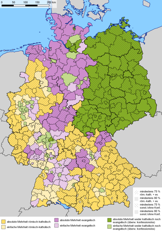
Deutsch: Dominierende Religionszugehörigkeit auf Landkreisebene nach Ergebnissen des Zensus 2011 in Deutschland. Violett: evangelisch, gelb: katholisch, grün: andere (konfessionslos, sonstige Religionen oder keine Angabe). Dunkel: absolute Mehrheit (> 50 %), hell: relative Mehrheit. Schraffuren: Anteil von Katholiken und Protestanten (rechtsdiagonale Schraffuren) bzw. Anderen (linksdiagonale Schraffuren) mindstestens 75 % (weite Schraffuren) und mindestens 90 % (enge Schraffuren). English: Dominant religious affiliation at district level according to the 2011 census in Germany. Mauve: Protestant, yellow: Catholic, green: Others (no denomination, other religion or not given). Dark: absolute majority (> 50 %), light: relative majority. Hatchings: Population share of Catholics and Protestants (right-inclined hatchings), and Others (left-inclined hatchings) at least 75 % (wide hatchings), and at least 90 % (narrow hatchings). |
| Data | |
| Fonte |
|
| Autore |
|
| Licenza (Riusare questo file) |
The files provided by the Statistische Ämter des Bundes und der Länder are open data, freely usable even for commercial purposes with no special permission needed, according to German law, see GeoNutzV (Verordnung zur Festlegung der Nutzungsbestimmungen für die Bereitstellung von Geodaten des Bundes) |
Licenza
Io, detentore del copyright su quest'opera, dichiaro di pubblicarla con le seguenti licenze:

|
È permesso copiare, distribuire e/o modificare questo documento in base ai termini della GNU Free Documentation License, Versione 1.2 o successive pubblicata dalla Free Software Foundation; senza alcuna sezione non modificabile, senza testo di copertina e senza testo di quarta di copertina. Una copia della licenza è inclusa nella sezione intitolata Testo della GNU Free Documentation License. |
Questo file è disponibile in base alle licenze Creative Commons Attribuzione-Condividi allo stesso modo 3.0 Unported, 2.5 Generico, 2.0 Generico e 1.0 Generico
- Tu sei libero:
- di condividere – di copiare, distribuire e trasmettere quest'opera
- di modificare – di adattare l'opera
- Alle seguenti condizioni:
- attribuzione – Devi fornire i crediti appropriati, un collegamento alla licenza e indicare se sono state apportate modifiche. Puoi farlo in qualsiasi modo ragionevole, ma non in alcun modo che suggerisca che il licenziante approvi te o il tuo uso.
- condividi allo stesso modo – Se remixi, trasformi o sviluppi il materiale, devi distribuire i tuoi contributi in base alla stessa licenza o compatibile all'originale.
Puoi scegliere la licenza che preferisci.
Cronologia del file
Fare clic su un gruppo data/ora per vedere il file come si presentava nel momento indicato.
| Data/Ora | Miniatura | Dimensioni | Utente | Commento | |
|---|---|---|---|---|---|
| attuale | 13:43, 30 ott 2019 | | 2 480 × 3 543 (558 KB) | Gretarsson | Hatchings added in order to depict population shares of ‘mainstream christians’ and others/atheists of more than 75 % and more than 90 %. Bodensee polygon added because in the administrative divisions shapefiles used the corresponding border sections of Baden-Wurttemberg and Bavaria follow the shoreline while those of Austria (Vorarlberg) and Switzerland (Thurgau, St. Gallen) are straight lines running straight through the lake; compressed using tinyPNG.com before upload |
| 09:19, 7 gen 2019 |  | 2 480 × 3 543 (1,91 MB) | Gretarsson | QGIS generated map with update of administrative borders (mainly Landkreise of Mecklenburg-Vorpommern), based on same data source as original version (Census 2011); colour of Landkreise with majority of people without religious belief and/or minority religions changed to greenish | |
| 13:50, 20 mar 2015 |  | 2 000 × 2 655 (937 KB) | RokerHRO | optipng -o7 -i0 → 41.10% decrease | |
| 11:34, 24 giu 2013 |  | 2 000 × 2 655 (1,55 MB) | Michael Sander | {{Information |Description=Dominierende Religionszugehörigkeit auf Landkreisebene nach Ergebnissen des Zensus 2011 in Deutschland. Lila: evangelisch, gelb: katholisch, blau: konfessionslos (und sonstige Religionen oder keine Angabe). Dunkel: absolute ... |
Pagine che usano questo file
Le seguenti 2 pagine usano questo file:
Utilizzo globale del file
Anche i seguenti wiki usano questo file:
- Usato nelle seguenti pagine di ar.wikipedia.org:
- Usato nelle seguenti pagine di bg.wikipedia.org:
- Usato nelle seguenti pagine di de.wikipedia.org:
- Usato nelle seguenti pagine di en.wikipedia.org:
- Usato nelle seguenti pagine di es.wikipedia.org:
- Usato nelle seguenti pagine di fa.wikipedia.org:
- Usato nelle seguenti pagine di fr.wikipedia.org:
- Usato nelle seguenti pagine di hr.wikipedia.org:
- Usato nelle seguenti pagine di id.wikipedia.org:
- Usato nelle seguenti pagine di ko.wikipedia.org:
- Usato nelle seguenti pagine di la.wikipedia.org:
- Usato nelle seguenti pagine di pl.wikipedia.org:
- Usato nelle seguenti pagine di ru.wikipedia.org:
- Usato nelle seguenti pagine di stq.wikipedia.org:
- Usato nelle seguenti pagine di zh.wikipedia.org: