File:Venus - 3D Perspective View of Maat Mons.jpg
Vai alla navigazione
Vai alla ricerca
Dimensioni di questa anteprima: 800 × 600 pixel. Altre risoluzioni: 320 × 240 pixel | 640 × 480 pixel | 1 024 × 768 pixel | 1 280 × 960 pixel | 2 560 × 1 920 pixel | 4 000 × 3 000 pixel.
File originale (4 000 × 3 000 pixel, dimensione del file: 1,09 MB, tipo MIME: image/jpeg)
| Questo file e la sua pagina di descrizione (discussione · modifica) si trovano su Wikimedia Commons (?) |
| Descrizione |
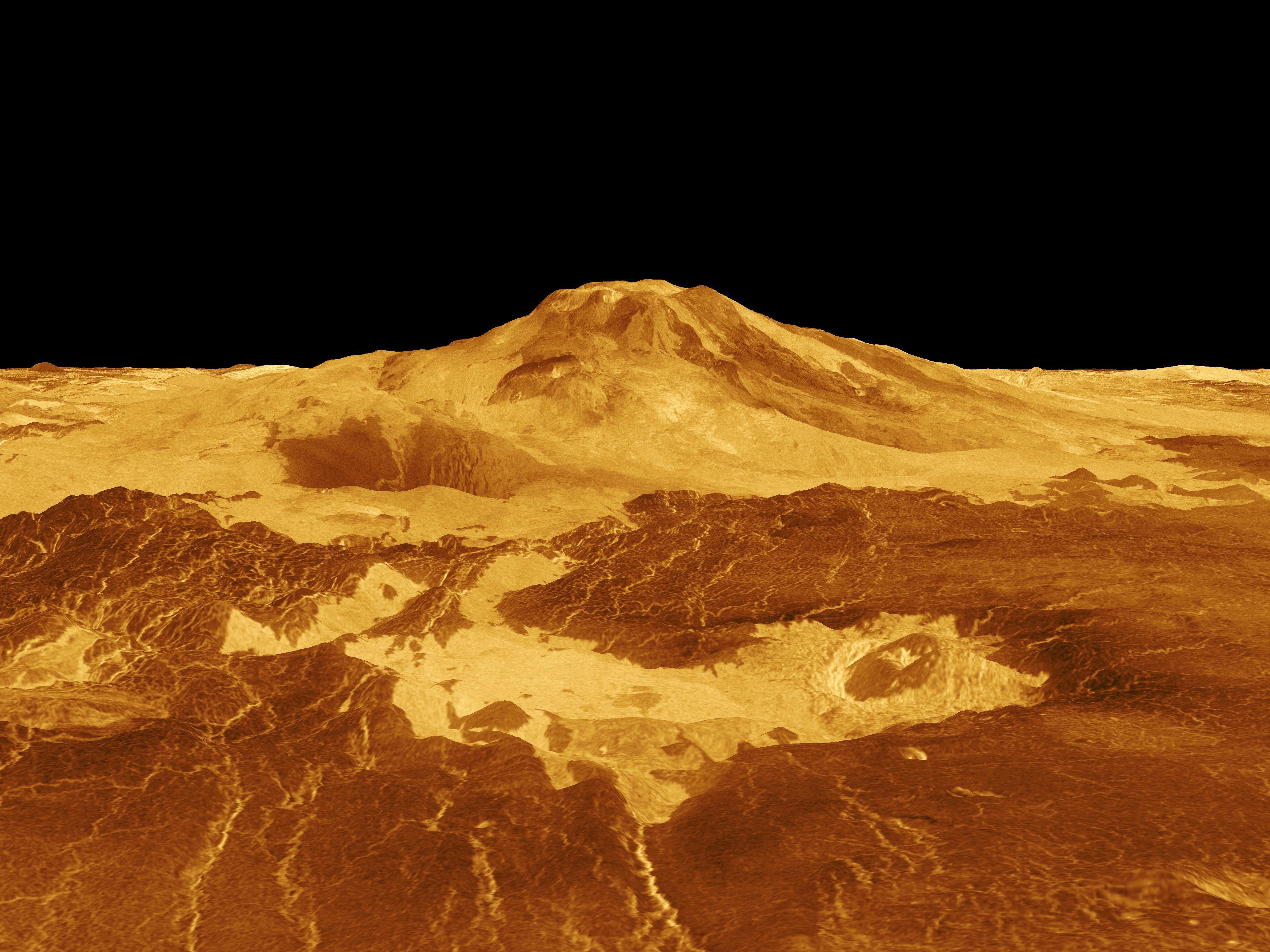
English: Maat Mons is displayed in this computer generated three-dimensional perspective of the surface of Venus. The viewpoint is located 634 kilometers (393 miles) north of Maat Mons at an elevation of 3 kilometers (2 miles) above the terrain. Lava flows extend for hundreds of kilometers across the fractured plains shown in the foreground, to the base of Maat Mons. The view is to the south with the volcano Maat Mons appearing at the center of the image on the horizon and rising to almost 5 kilometers (3 miles) above the surrounding terrain. Maat Mons is located at approximately 0.9 degrees north latitude, 194.5 degrees east longitude with a peak that ascends to 8 kilometers (5 miles) above the mean surface. Maat Mons is named for an Egyptian Goddess of truth and justice. Magellan synthetic aperture radar data is combined with radar altimetry to develop a three-dimensional map of the surface. The vertical scale in this perspective has been exaggerated 10 times. Rays cast in a computer intersect the surface to create a three-dimensional perspective view. Simulated color and a digital elevation map developed by the U.S. Geological Survey are used to enhance small-scale structure. The simulated hues are based on color images recorded by the Soviet Venera 13 and 14 spacecraft. The image was produced by the Solar System Visualization project and the Magellan Science team at the JPL Multimission Image Processing Laboratory and is a single frame from a video released at the April 22, 1992 news conference. Українська: Панорама Венери. Потоки лави на 400-км ділянці поверхні Венери |
|||||
| Data | ||||||
| Fonte | http://photojournal.jpl.nasa.gov/catalog/PIA00106 | |||||
| Autore |
|
|||||
| Licenza (Riusare questo file) |
|

Cronologia del file
Fare clic su un gruppo data/ora per vedere il file come si presentava nel momento indicato.
| Data/Ora | Miniatura | Dimensioni | Utente | Commento | |
|---|---|---|---|---|---|
| attuale | 12:34, 14 feb 2009 | | 4 000 × 3 000 (1,09 MB) | Complex01 | {{Information |Description={{en|1=Maat Mons is displayed in this computer generated three-dimensional perspective of the surface of Venus. The viewpoint is located 634 kilometers (393 miles) north of Maat Mons at an elevation of 3 kilometers (2 miles) abo |
Pagine che usano questo file
La seguente pagina usa questo file:
Utilizzo globale del file
Anche i seguenti wiki usano questo file:
- Usato nelle seguenti pagine di ar.wikipedia.org:
- Usato nelle seguenti pagine di ca.wikipedia.org:
- Usato nelle seguenti pagine di cy.wikipedia.org:
- Usato nelle seguenti pagine di en.wikipedia.org:
- Usato nelle seguenti pagine di es.wikipedia.org:
- Usato nelle seguenti pagine di eu.wikipedia.org:
- Usato nelle seguenti pagine di fr.wikipedia.org:
- Usato nelle seguenti pagine di gl.wikipedia.org:
- Usato nelle seguenti pagine di he.wikipedia.org:
- Usato nelle seguenti pagine di ja.wikipedia.org:
- Usato nelle seguenti pagine di ja.wikibooks.org:
- Usato nelle seguenti pagine di mk.wikipedia.org:
- Usato nelle seguenti pagine di nl.wikipedia.org:
- Usato nelle seguenti pagine di pl.wikipedia.org:
- Usato nelle seguenti pagine di th.wikipedia.org:
- Usato nelle seguenti pagine di tr.wikipedia.org:
- Usato nelle seguenti pagine di uk.wikipedia.org:
- Usato nelle seguenti pagine di www.wikidata.org:
- Usato nelle seguenti pagine di zh.wikipedia.org: