File:Unibicameral Map.svg
Vai alla navigazione
Vai alla ricerca

Dimensioni di questa anteprima PNG per questo file SVG: 800 × 406 pixel. Altre risoluzioni: 320 × 162 pixel | 640 × 325 pixel | 1 024 × 520 pixel | 1 280 × 650 pixel | 2 560 × 1 299 pixel | 940 × 477 pixel.
File originale (file in formato SVG, dimensioni nominali 940 × 477 pixel, dimensione del file: 1,7 MB)
| Questo file e la sua pagina di descrizione (discussione · modifica) si trovano su Wikimedia Commons (?) |
W3C-validity not checked.
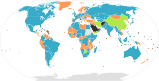
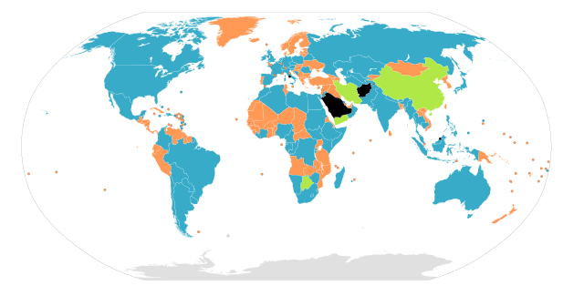
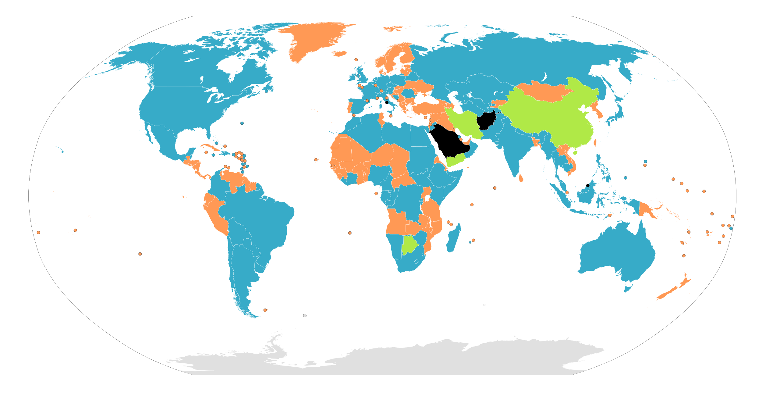
| Descrizione | Map of the legislative organizations of the countries of the world, originally by Aris Katsaris. Note: This only shows national legislatures, federations with sublegislatures are not required to have sublegislatures on the same model as their country: The United States has a bicameral legislature, the State of Nebraska has a unicameral legislature. Similarly, although Canada has a bicameral legislature, all of its provinces and territories have unicameral legislatures. Note: Any official "legislature", including unelected and powerlessly limited ones, are counted. Countries without a functioning legislature, such as countries governed by a military junta, are coloured black. |
| Data | 22 giugno 2009, 11:39 (UTC) |
| Fonte | |
| Autore |
|
Legend
English (en): Map of nations based on their legislatures.
Nations with a unicameral form of legislature.
Nations with a unicameral legislature and an advisory body.
Nations with a bicameral form of legislature.
Nations with no form of legislature.
Data not available.
العربية (ar): خريطة الدول بناءً على برلماناتها.
دول لديها برلمان بغرفة واحدة.
دول لديها برلمان من مجلسين.
دول ليس لديها برلمان.
البيانات غير متوفرة.
فارسی (fa): نقشهٔ نهادهای قانونگذار جهان بر پایهٔ نظام مجلس
نهاد قانونگذاری تکمجلسی
نهاد قانونگذاری دومجلسی
نهاد قانونگذاری تکمجلسی و یک نهاد مشورتی
بی مجلس
بی داده
русский (Ru): Законодательная власть.
Однопалатные парламенты.
Однопалатные парламенты с консультативным органом.
Двухпалатные парламенты.
Парламент отсутствует.
Нет данных.
Deutsch (de): Staaten und ihre Legislative.
Staaten mit Einkammersystem.
Staaten mit Einkammersystem und Beratungsorgan.
Staaten mit Zweikammersystem.
Staaten ohne Legislative.
Ohne Daten.
français (fr): Une carte des pays basée sur leurs systèmes parlementaires.
Pays avec un parlement monocaméral.
Pays avec un parlement bicaméral.
Pays sans forme de parlement.
Données non disponibles.
македонски (mk): Карта на државите според видот на законодавниот дом.
Држави со еднодомно собрание.
Држави со дводомно собрание.
Држави без формален законодавен дом.
Нема податоци.
Nederlands (nl): Kaart met landen gebaseerd op hun parlementssysteem.
Landen met een eenkamerstelsel.
Landen met een eenkamerstelsel en een adviesorgaan.
Landen with a tweekamerstelsel.
Landen zonder vorm van parlement.
Gegevens niet beschikbaar.
español (es): Mapa de naciones basado en legislaciones.
Naciones con legislación unicameral.
Naciones con legislación unicameral y un consejo consultivo.
Naciones con legislación bicameral.
Naciones sin ninguna forma de legislación.
Informacion no disponible.
italiano (it): Mappa dei sistemi parlamentari nel mondo.
Nazioni con parlamento unicamerale.
Nazioni con parlamento bicamerale.
Nazioni senza parlamento.
Dati non disponibili.
dansk (da): Kort over verdens lande baseret på deres parlamenter.
Nationer med et etkammersystem.
Nationer med et tokammersystem.
Nationer uden et parlament.
Intet data tilgængeligt.
magyar (hu): Világtérkép az államok törvényhozása szerint
Államok egykamarás törvényhozással
Államok kétkamarás törvényhozással
Államok törvényhozási forma nélkül
nincs adat
català (ca): Mapa d'estats segons llurs òrgans legislatius.
Estats monocamerals.
Estats monocamerals que compten amb un òrgan consultiu.
Estats bicamerals.
Estats sense òrgan legislatiu.
Sense dades.
Türkçe (tr): Milletlerin yasama organlarına göre haritası.
Tek meclisli sisteme sahip devletler.
Tek meclisli bir sistem ve bir danışma organı olan devletler.
Çift meclisli sisteme sahip devletler.
Yasama organı olmayan devletler.
Verisiz.

|
È permesso copiare, distribuire e/o modificare questo documento in base ai termini della GNU Free Documentation License, Versione 1.2 o successive pubblicata dalla Free Software Foundation; senza alcuna sezione non modificabile, senza testo di copertina e senza testo di quarta di copertina. Una copia della licenza è inclusa nella sezione intitolata Testo della GNU Free Documentation License. |
| Questo file è disponibile in base alla licenza Creative Commons Attribuzione-Condividi allo stesso modo 3.0 Unported | ||
| ||
| Questo tag di copyright è stato aggiunto nell'ambito dell'aggiornamento della licenza dei progetti Wikimedia. |
Registro originale del caricamento
This image is a derivative work of the following images:
- File:Unibicameral_Map.png licensed with GFDL-en, GFDL-user-en-note
- 2009-06-08T11:46:57Z Middayexpress 1262x628 (17539 Bytes) updated
- 2009-06-08T11:45:29Z Middayexpress 1262x628 (17539 Bytes) Updated.
- 2009-04-18T12:49:18Z SeNeKa 1262x628 (17534 Bytes) updated
- 2009-04-18T09:53:11Z SeNeKa 1262x628 (16784 Bytes) Updated
- 2007-06-19T16:31:05Z Gadren 1262x628 (46103 Bytes) == Summary == Map of unicameral and bicameral parliaments around the world. Created by [[:en:User:Aris Katsaris|Aris Katsaris]]. Orange is for unicameral, blue is for bicameral and gray is neither. == Licensing == {{GFDL-use
- 2007-05-05T18:17:47Z Gadren 1262x628 (46144 Bytes) Map of unicameral and bicameral parliaments around the world. Created by [[:en:User:Aris Katsaris|Aris Katsaris]]. Orange is for unicameral, blue is for bicameral and gray is neither.
- 2006-06-22T22:13:33Z Nightstallion 1262x628 (46090 Bytes) slovenia's bicameral.
- 2006-04-23T21:37:14Z Metarhyme 1262x628 (46084 Bytes) == Summary == Map of unicameral and bicameral parliaments around the world. Created by [[:en:User:Aris Katsaris|Aris Katsaris]]. Orange is for unicameral, blue is for bicameral and gray is neither. == Licensing == {{GFDL-use
- 2006-02-13T06:02:50Z Jaranda 1262x628 (46191 Bytes)
- 2005-11-11T21:57:05Z Moyogo 1262x628 (27224 Bytes) fixed DR Congo
- 2005-10-06T07:06:09Z Gabbe 1262x628 (27124 Bytes) Fix Kalimantan
- 2005-10-05T21:10:43Z Gabbe 1262x628 (27137 Bytes) fixed Indonesia
- 2005-10-04T07:03:25Z Gabbe 1262x628 (27151 Bytes) Map of unicameral and bicameral parliaments around the world. Created by [[:en:User:Aris Katsaris|Aris Katsaris]].
- 2005-09-05T06:04:29Z Gabbe 1262x628 (27060 Bytes) Map of unicameral and bicameral parliaments around the world. Created by [[en:User:Aris Katsaris|]].
- File:BlankMap-World6.svg licensed with PD-self
- 2009-06-13T16:59:33Z NuclearVacuum 940x477 (1671030 Bytes) fixed the global outline on my upload
- 2009-06-13T16:55:42Z NuclearVacuum 940x477 (1671080 Bytes) Similar to how Serbia and Kosovo are separated, I made the outline for Abkhazia, South Ossetia, and Transnistria
- 2009-05-13T13:58:14Z SkyBon 940x477 (1601527 Bytes) fixed
- 2009-05-13T03:24:33Z Unionhawk 940x477 (1605234 Bytes) Reverted to version as of 01:00, 20 March 2009
- 2009-05-12T15:39:38Z SkyBon 940x477 (1601502 Bytes) oops
- 2009-05-12T15:38:35Z SkyBon 477x940 (1601502 Bytes) code cleanup
- 2009-03-20T01:00:21Z AzaToth 940x477 (1605234 Bytes) Fix errorious duplicate end tag of id='ma'/> Specified style, dc:format, and dc:title tag to be CDATA
- 2009-03-19T23:57:36Z AzaToth 940x477 (1605207 Bytes) Fix duplicate ID (was two "mf", changed second to "mf-")
- 2009-01-23T13:36:09Z Yug 940x477 (1605206 Bytes) The English colours are controversial: ink consuming, not print friendly [black&white], CIA based.
- 2009-01-19T18:37:07Z Emilfaro 940x477 (1605212 Bytes) CSS edited to bring in accordance with [[:en:Wikipedia:WikiProject Maps]] Standard convention on the Map colors.
- 2008-11-02T02:13:36Z Lokal Profil 940x477 (1605206 Bytes) Reverted to version as of 00:30, 29 March 2008. This version includes metadata about title and license of image. The SVG validator is broken with regards to metadata (and other thing) see [[:Template talk:ValidSVG]] for more
- 2008-11-02T01:32:33Z Victormoz 940x477 (1601613 Bytes)
- 2008-11-02T01:28:12Z Victormoz 940x477 (1601629 Bytes)
- 2008-11-02T01:14:36Z Victormoz 940x477 (1601705 Bytes)
- 2008-03-29T00:30:24Z Canuckguy 940x477 (1605206 Bytes) fixed error found: Sao Tome (code "st") was messing with the coast tag ("coast" ends in "st") on some maps. Changed "land", "coast", "circle" and "sub" tags to "landxx", "coastxx", "circlexx" and "subxx" to prevent further
- 2008-02-28T03:55:15Z Canuckguy 940x477 (1604123 Bytes) re-added missing Honduras
- 2008-02-27T21:20:02Z Canuckguy 940x477 (1602296 Bytes) make borders touch, add circles for French DOMs and Chinese SARs, undo rounding of numbers, delete some extraneous nodes.
- 2008-02-02T18:38:58Z AzaToth 940x477 (881503 Bytes) rounding the values to near whole numbers. I don't think the decimals will do any visible difference at all.
- 2007-12-14T02:57:29Z Lokal Profil 940x477 (1616830 Bytes) a class fix to France. Moved the france group further down to not cover andorra circle etc. Got rid of som translate tags by recalculating the paths.
- 2007-12-09T20:27:34Z Canuckguy 940x477 (1616719 Bytes) thinner line for borders
- 2007-12-09T03:58:49Z Canuckguy 940x477 (1616984 Bytes) changes to France (see description and discussion pages), added a class for islands without an international border that makes the coastline thinner
- 2007-11-08T22:20:44Z Ketiltrout 940x477 (1614834 Bytes) Move Disko Island and the Bahamas back to their rightful places
- 2007-10-06T20:29:38Z Canuckguy 940x477 (1614582 Bytes) removed unneeded classes
- 2007-09-25T02:52:30Z Canuckguy 940x477 (1631712 Bytes) Moved css classes around and added a few additional instructions in the css for colouring the map. Fixed a few errors that were reverted.
- 2007-09-17T22:06:35Z Lokal Profil 940x477 (1632888 Bytes) aq_land (and arctic) to aq, removed two formating cludges which didn't make any visual difference, Replaced swaziland by formating cludge around swaziland and renamed, removed duplicat "ki" entry (probably left by me last tim
- 2007-09-13T18:52:32Z Lokal Profil 940x477 (1635420 Bytes) Basically same edits as Canuckguy but in a text editor so as to eliminate Inksacape junk code and preserve the style structure. Also made sure all circles are above the surrounding countries.
- 2007-09-10T05:54:39Z Canuckguy 940x477 (1915635 Bytes) Simplified circles - now in same layer as countries (making the whole file one layer), simplified a few other things as detailed on the changes in the descrption on the talk page.
- 2007-09-09T03:03:49Z Lokal Profil 940x477 (1632593 Bytes) Added ISO-id to Mongolia, Bhutan and Andorra circle, Corrected id of Malawi, made "Swaziland border path" transparent so that colour of underlying path becomes visible. Also removed Inkscape objects, cleaned out a lot of blan
- 2007-08-29T21:14:30Z H2g2bob 940x477 (1630393 Bytes) Remove class="..." from elements if parent has same or similar class, allowing for inheritance of style rules.
- 2007-08-25T22:15:44Z H2g2bob 940x477 (1686400 Bytes) Update to map to include styles in CSS stylesheet using <svg:style> tags. This allows changing the style of the entire map in one go. This edit was done in a text editor.
- 2007-08-22T00:27:08Z Canuckguy 940x477 (2019787 Bytes) fixed a few problems with previous version (restored small countries circles, fixed problem with Germany and Serbia)
- 2007-07-08T21:00:39Z Andrew pmk 940x477 (2021488 Bytes) Remove lots of small islands which are not visible or barely visible at normal zoom levels; clean up borders so that boundaries are included in the main country groups, rather than being separate objects; make background all
- 2007-07-04T00:04:59Z AzaToth 940x477 (2265956 Bytes) Minor optimizations using perl SVG::Parser and SVG modules (reparsing the tree)
- 2007-01-09T03:38:38Z Roke 940x477 (2370958 Bytes) Reverted to earlier revision
- 2007-01-09T03:37:25Z Roke 940x477 (2549763 Bytes) hidden layers: separate non-sovereign & sovereign circles, text
- 2006-12-29T04:02:15Z Canuckguy 940x477 (2370958 Bytes)
- 2006-12-10T10:34:46Z Brianski 940x477 (2209317 Bytes) re-optimized with optisvg.pl
- 2006-11-26T06:54:55Z Canuckguy 940x477 (2370957 Bytes) deleted Aksai Chin, awarded territory to China (nation of control, as India is pictured as the nation of control over Arunchal Pradesh). Revised from previous version by me, so may need optimizing by Brianski's tool again (s
- 2006-11-23T11:27:06Z Brianski 940x477 (2273821 Bytes) optimized using Brian Szymanski's optisvg.pl
- 2006-11-21T23:09:04Z Canuckguy 940x477 (2440482 Bytes) a few more minor tweaks
- 2006-11-12T04:13:48Z Hexagon1 940x477 (2365940 Bytes) Canuckguy's fixed some errors
- 2006-11-12T02:02:50Z Hexagon1 940x765 (2318315 Bytes) Detailed SVG map with grouping enabled to connect all non-contiguous parts of a country's territory for easy colouring.
Uploaded with derivativeFX
Cronologia del file
Fare clic su un gruppo data/ora per vedere il file come si presentava nel momento indicato.
| Data/Ora | Miniatura | Dimensioni | Utente | Commento | |
|---|---|---|---|---|---|
| attuale | 00:14, 29 lug 2023 | | 940 × 477 (1,7 MB) | ICommandeth | Taliban government doesn't have a legislature |
| 22:05, 17 apr 2023 |  | 940 × 477 (1,7 MB) | ICommandeth | Brunei does not have a legislature | |
| 19:15, 27 gen 2023 |  | 940 × 477 (1,7 MB) | Extended Cut | Nepal has a bicameral parliament | |
| 01:50, 7 ott 2022 |  | 940 × 477 (1,64 MB) | Duonaut | yemen has an advisory shura council | |
| 06:26, 17 giu 2022 |  | 940 × 477 (1,7 MB) | TEMPO156 | Update Qatar and Afghanistan. Both are quasi-consultative but have real political power | |
| 11:26, 11 dic 2021 |  | 940 × 477 (1,7 MB) | Eyesnore | Fixed Senegal | |
| 11:18, 11 dic 2021 |  | 940 × 477 (1,7 MB) | Eyesnore | Egypt is now bicameral. Mauritania is now unicameral. Turkmenistan is now bicameral. | |
| 19:57, 2 giu 2020 |  | 940 × 477 (1,7 MB) | CatOnMars | China is a nation with an unicameral legislature and an advisory body.(see Chinese People's Political Consultative Conference & National People's Congress) HK and Macao are literally Special Administrative Regions (SAR, provincial-level) under Beijing, whose legislatures are not national.(see 2017 National People's Congress election in Hong Kong) | |
| 16:46, 17 mag 2019 |  | 940 × 477 (1,71 MB) | Mapache del Raton | Cote d'Ivoire is bicameral (since 2016), Senegal is no longer bicameral (since 2012) and Cameroon is now bicameral (since 2013) | |
| 09:52, 27 ago 2017 |  | 940 × 477 (1,69 MB) | Glide08 | Botswana is not unambiguously Bicameral and Iran is not unambiguously Unicameral. Both the Iranian Assembly of Experts and the Motswana House of Chiefs are advisory bodies to the Parliament that are ambiguously upper houses. |
Pagine che usano questo file
Le seguenti 3 pagine usano questo file:
Utilizzo globale del file
Anche i seguenti wiki usano questo file:
- Usato nelle seguenti pagine di af.wikipedia.org:
- Usato nelle seguenti pagine di ar.wikipedia.org:
- Usato nelle seguenti pagine di ast.wikipedia.org:
- Usato nelle seguenti pagine di as.wikipedia.org:
- Usato nelle seguenti pagine di az.wikipedia.org:
- Usato nelle seguenti pagine di be.wikipedia.org:
- Usato nelle seguenti pagine di bg.wikipedia.org:
- Usato nelle seguenti pagine di bs.wikipedia.org:
- Usato nelle seguenti pagine di ca.wikipedia.org:
- Usato nelle seguenti pagine di cs.wikipedia.org:
- Usato nelle seguenti pagine di cy.wikipedia.org:
- Usato nelle seguenti pagine di de.wikipedia.org:
- Usato nelle seguenti pagine di diq.wikipedia.org:
- Usato nelle seguenti pagine di el.wikipedia.org:
- Usato nelle seguenti pagine di en.wikipedia.org:
- Usato nelle seguenti pagine di en.wikivoyage.org:
- Usato nelle seguenti pagine di es.wikipedia.org:
- Usato nelle seguenti pagine di et.wikipedia.org:
- Usato nelle seguenti pagine di eu.wikipedia.org:
- Usato nelle seguenti pagine di fa.wikipedia.org:
- Usato nelle seguenti pagine di fi.wikipedia.org:
- Usato nelle seguenti pagine di fr.wikipedia.org:
- Usato nelle seguenti pagine di fr.wiktionary.org:
Visualizza l'utilizzo globale di questo file.