File:Stereo Pair, Lake Palanskoye Landslide, Kamchatka Peninsula, Russia.jpg
File originale (519 × 800 pixel, dimensione del file: 583 KB, tipo MIME: image/jpeg)
| Questo file e la sua pagina di descrizione (discussione · modifica) si trovano su Wikimedia Commons (?) |
| This file contains one or more legible stereograms, but is not itself formatted for 3D viewing. (It might be possible to extract pure stereograms from this file for more convenient viewing. Please see the guidelines covering overwriting.) Stereograms are stereoscopic images or animations which combine left and right frames showing slightly different visual angles to allow for 3D perception.
The stereogram uses the side-by-side cross-view method. The left frame shows the right eye's perspective, and the right frame the left eye's perspective. It might be possible to view this image without a viewing device by crossing your eyes to visually combine the frames. |
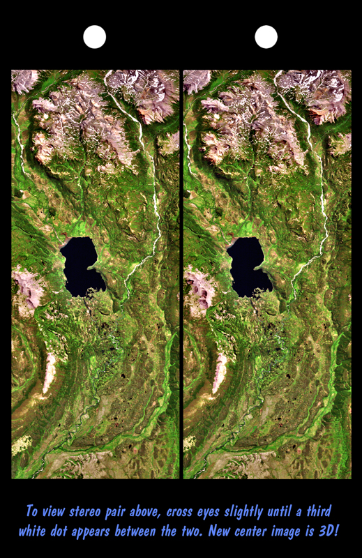
The Lake Palanskoye in northern Kamchatka was formed when a large landslide disrupted the drainage pattern, forming a natural dam. The area is volcanically and tectonically active and it is likely that the landslide -- which covers about 80 square kilometers (30 square miles) -- was triggered by an earthquake sometime in the past 10,000 years. The source area of the landslide is the ridge between the two bright rocky features to the lower left of the lake. In 3-D, the steep topographic scar at the head of the slide and the broad expanse of hummocky landslide debris that covers the valley just below the lake are visible. This Landsat / SRTM stereoscopic view is an enhanced true color image: Vegetation appears green, rocks are brownish, snow is white and water (such as the lake) appears very dark.
This stereoscopic image pair was generated using topographic data from SRTM combined with a Landsat 7 satellite image collected the previous summer. The topography data were used to create two differing perspectives of a single image -- one for each eye. Depending on its elevation, each point in the image was shifted slightly. When stereoscopically merged, the result is a vertically exaggerated view of the Earth's surface in its full three dimensions.
Landsat satellites have provided visible light and infrared images of the Earth continuously since 1972. SRTM topographic data match the 30 meter (99 foot) spatial resolution of most Landsat images and will provide a valuable complement for studying the historic and growing Landsat data archive. The Landsat 7 Thematic Mapper image used here was provided to the SRTM project by the United States Geological Survey, Earth Resources Observation Systems (EROS) Data Center, Sioux Falls, South Dakota.
The Shuttle Radar Topography Mission (SRTM), launched on February 11, 2000, used the same radar instrument that comprised the Spaceborne Imaging Radar-C/X-Band Synthetic Aperture Radar (SIR-C/X-SAR) that flew twice on the Space Shuttle Endeavour in 1994. SRTM was designed to collect three-dimensional measurements of the Earth's surface on its 11-day mission. To collect the 3-D data, engineers added a 60-meter-long (200-foot) mast, an additional C-band imaging antenna, and improved tracking and navigation devices. The mission is a cooperative project between the National Aeronautics and Space Administration (NASA), the National Imagery and Mapping Agency (NIMA) and the German (DLR) and Italian (ASI) space agencies. It is managed by NASA's Jet Propulsion Laboratory, Pasadena, CA, for NASA's Earth Science Enterprise, Washington, DC.
Size: 48 by 20 kilometers (30 by 12 miles) Location: 58.8 deg. North lat., 160.8 deg. East lon. Orientation: North toward the left Image Data: Landsat bands 1, 2, and 3 shown in blue, green and red Original Data Resolution: SRTM and Landsat, 30 meters (99 feet) Date Acquired: February 12, 2000 (SRTM); August 1, 1999 (Landsat)
http://visibleearth.nasa.gov/view_rec.php?id=338
| Questo file è nel pubblico dominio perché creato dalla NASA. La politica sul copyright della NASA afferma che «il materiale della NASA non è protetto da copyright a meno che non sia specificato altrimenti». (NASA copyright policy e JPL Image Use Policy). | ||
 |
Attenzione:
|
.jpg)
Cronologia del file
Fare clic su un gruppo data/ora per vedere il file come si presentava nel momento indicato.
| Data/Ora | Miniatura | Dimensioni | Utente | Commento | |
|---|---|---|---|---|---|
| attuale | 02:52, 27 ott 2005 | | 519 × 800 (583 KB) | Brian0918 | The Lake Palanskoye in northern Kamchatka was formed when a large landslide disrupted the drainage pattern, forming a natural dam. The area is volcanically and tectonically active and it is likely that the landslide -- which covers about 80 square kilomet |
Pagine che usano questo file
La seguente pagina usa questo file:
Utilizzo globale del file
Anche i seguenti wiki usano questo file:
- Usato nelle seguenti pagine di en.wikipedia.org:
- Usato nelle seguenti pagine di en.wiktionary.org:
- Usato nelle seguenti pagine di fr.wikipedia.org:
- Usato nelle seguenti pagine di fr.wikibooks.org:
- Usato nelle seguenti pagine di zh.wikipedia.org: