File:Red dawn 1984 movie start of ww3.PNG
Vai alla navigazione
Vai alla ricerca

Dimensioni di questa anteprima: 800 × 359 pixel. Altre risoluzioni: 320 × 144 pixel | 640 × 287 pixel | 1 400 × 628 pixel.
File originale (1 400 × 628 pixel, dimensione del file: 49 KB, tipo MIME: image/png)
| Questo file e la sua pagina di descrizione (discussione · modifica) si trovano su Wikimedia Commons (?) |

|
This map, as well as other fictitious maps, is fictitious or too incorrect (i.e. due to anachronism) to be used in real-life contexts (contemporary or historic). It may have some visual elements that are similar to official maps such as colors or certain layout features, but they are NOT official and don't have any official recognition. |
Dettagli
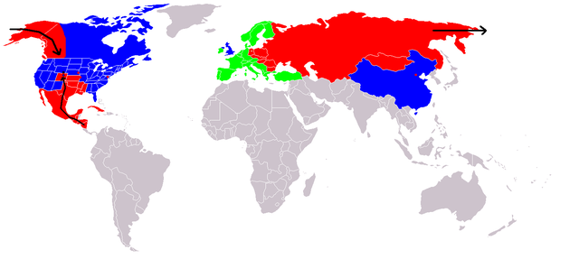
Map of fictional events in the 1984 movie Red Dawn, at the start of World War III.
- Blue = US and allies (United Kingdom "England", China "600 million screaming Chinamen", presumably Unoccupied Canada)
- Green = Neutral (Europe, "they're sitting this one out")
- Red = USSR and allies (showing USSR invasion of Alaska "stopped butt cold" at the contiguous 48 US border, Occupied Canadian Provinces of British Columbia, Western portion of Alberta and the Yukon Territory, Honduras, El Salvador, and Guatemala fall, Mexico in revolution, Texas described as being behind enemy lines, Oklahoma and most of Kansas, Louisiana, Arkansas, and Missouri probably overrun too, Colorado where the movie is set - invasion force stopped at Cheyenne, Wyoming. Blue circle shows Denver under siege.)
- Grey = Unknown
- Red squares = use of Soviet nuclear weapons - Beijing "there were", Washington, Kansas City & Omaha
At the end of the movie the US is implied on a plaque as having won the war, although how they did it is not explained.
If The US stopped them at the Mississippi River, then the color used for the US state Mississippi is incorrect. Mississippi would be part of F.A. (Free America) not occupied as the map indicates.
Licenza

|
È permesso copiare, distribuire e/o modificare questo documento in base ai termini della GNU Free Documentation License, Versione 1.2 o successive pubblicata dalla Free Software Foundation; senza alcuna sezione non modificabile, senza testo di copertina e senza testo di quarta di copertina. Una copia della licenza è inclusa nella sezione intitolata Testo della GNU Free Documentation License. |
| Questo file è disponibile in base alla licenza Creative Commons Attribuzione-Condividi allo stesso modo 3.0 Unported | ||
| ||
| Questo tag di copyright è stato aggiunto nell'ambito dell'aggiornamento della licenza dei progetti Wikimedia. |

|
Questa immagine (categorizzazione automatica: fictional map) o tutte le immagini in questa categoria o galleria dovrebbero essere ricreate usando grafica vettoriale come file SVG. Questo offre diversi vantaggi: vedi Commons:Media for cleanup per maggiori informazioni. Se è disponibile una versione in formato SVG di questa immagine, per favore caricala. Dopo aver caricato un file SVG, sostituisci questo avviso con il template {{Vector version available|nome_immagine.svg}}.
|
Cronologia del file
Fare clic su un gruppo data/ora per vedere il file come si presentava nel momento indicato.
| Data/Ora | Miniatura | Dimensioni | Utente | Commento | |
|---|---|---|---|---|---|
| attuale | 22:09, 23 dic 2008 | | 1 400 × 628 (49 KB) | Shibo77 | {{Information |Description=.. |Source=Roke |Date=.. |Author=Roke |Permission=.. |other_versions=.. }} <!--{{ImageUpload|basic}}--> |
| 14:36, 18 giu 2008 |  | 1 400 × 628 (49 KB) | Peephole | {{Information |Description= |Source= |Date= |Author= |Permission= |other_versions= }} | |
| 03:14, 5 ott 2007 |  | 1 400 × 628 (49 KB) | Hoshie | added Cabinda (between Angola and Zaire), fixed YAR/PDRY boundary. | |
| 21:17, 10 set 2007 |  | 1 400 × 628 (49 KB) | Bart133 | == Summary == Map of fictional events in 1984 movie Red Dawn, at the start of World War III *Blue = US and allies (United Kingdom, China "600 million screaming Chinamen", presumably Unoccupied Canada) *Green = Neutral (Europe, "they're sitting this one o | |
| 02:54, 13 apr 2006 |  | 1 400 × 628 (49 KB) | Roke~commonswiki | Map of fictional events in 1984 movie Red Dawn, at the start of World War III Blue = US and allies (England, China "600 million screaming Chinamen", presumably Canada) Green = Neutral (Europe, "theyre sitting this one out") Red = USSR and allies (showing |
Pagine che usano questo file
La seguente pagina usa questo file:
Utilizzo globale del file
Anche i seguenti wiki usano questo file:
- Usato nelle seguenti pagine di ar.wikipedia.org:
- Usato nelle seguenti pagine di ca.wikipedia.org:
- Usato nelle seguenti pagine di cy.wikipedia.org:
- Usato nelle seguenti pagine di de.wikipedia.org:
- Usato nelle seguenti pagine di en.wikipedia.org:
- Usato nelle seguenti pagine di eo.wikipedia.org:
- Usato nelle seguenti pagine di es.wikipedia.org:
- Usato nelle seguenti pagine di eu.wikipedia.org:
- Usato nelle seguenti pagine di fi.wikipedia.org:
- Usato nelle seguenti pagine di fr.wikipedia.org:
- Usato nelle seguenti pagine di id.wikipedia.org:
- Usato nelle seguenti pagine di ja.wikipedia.org:
- Usato nelle seguenti pagine di ko.wikipedia.org:
- Usato nelle seguenti pagine di ms.wikipedia.org:
- Usato nelle seguenti pagine di nds.wikipedia.org:
- Usato nelle seguenti pagine di nl.wikipedia.org:
- Usato nelle seguenti pagine di no.wikipedia.org:
- Usato nelle seguenti pagine di pl.wikipedia.org:
- Usato nelle seguenti pagine di pt.wikipedia.org:
- Usato nelle seguenti pagine di ru.wikipedia.org:
- Usato nelle seguenti pagine di simple.wikipedia.org:
- Usato nelle seguenti pagine di sv.wikipedia.org:
- Usato nelle seguenti pagine di uk.wikipedia.org:
- Usato nelle seguenti pagine di zh.wikipedia.org: