File:End.of.Roman.rule.in.Britain.383.410.jpg

File originale (2 582 × 3 220 pixel, dimensione del file: 1 010 KB, tipo MIME: image/jpeg)
| Questo file e la sua pagina di descrizione (discussione · modifica) si trovano su Wikimedia Commons (?) |
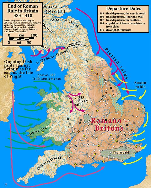
| Descrizione | End of Roman Rule in Britain, 383–410 |
| Data | |
| Fonte |
Based on Jones & Mattingly's Atlas of Roman Britain (ISBN 978-1-84217-06700, 1990, reprinted 2007); Mattingly's Imperial Possession ( ISBN 978-0-140-14822-0, 2006); Higham's Rome, Britain, and the Anglo-Saxons (ISBN 1-85264-022-7, 1992); Frere's Britannia (ISBN 0-7102-1215-1, 1987); and Snyder's An Age of Tyrants (ISBN 978-0-631-22260-6) — the sources are cited in the image legend — Locations of towns (fortified and unfortified) are given on p. 156, with tribal civitates and coloniae specified on p. 154, of Atlas of Roman Britain. Specification of the Romanized regions of Britain are also from the Atlas, p. 151. The "Departure Dates" are found in the cited sources, and are generally known. The Pictish, Saxon, and Scoti raids are found in the cited sources, as is the date of the Irish settlements in Wales. Frere suggests (p. 355) that it was the Irish who sacked Wroxeter c. 383. The locations of the Irish settlements is from the locations of inscription stones given in File:Britain.Deisi.Laigin.jpg as of 2010-10-11, which cites its sources of information.
|
| Autore | my work |
- Tu sei libero:
- di condividere – di copiare, distribuire e trasmettere quest'opera
- di modificare – di adattare l'opera
- Alle seguenti condizioni:
- attribuzione – Devi fornire i crediti appropriati, un collegamento alla licenza e indicare se sono state apportate modifiche. Puoi farlo in qualsiasi modo ragionevole, ma non in alcun modo che suggerisca che il licenziante approvi te o il tuo uso.
- condividi allo stesso modo – Se remixi, trasformi o sviluppi il materiale, devi distribuire i tuoi contributi in base alla stessa licenza o compatibile all'originale.

|
Questa immagine (categorizzazione automatica: historical map) o tutte le immagini in questa categoria o galleria dovrebbero essere ricreate usando grafica vettoriale come file SVG. Questo offre diversi vantaggi: vedi Commons:Media for cleanup per maggiori informazioni. Se è disponibile una versione in formato SVG di questa immagine, per favore caricala. Dopo aver caricato un file SVG, sostituisci questo avviso con il template {{Vector version available|nome_immagine.svg}}.
|


Cronologia del file
Fare clic su un gruppo data/ora per vedere il file come si presentava nel momento indicato.
| Data/Ora | Miniatura | Dimensioni | Utente | Commento | |
|---|---|---|---|---|---|
| attuale | 22:07, 18 ott 2010 | | 2 582 × 3 220 (1 010 KB) | Notuncurious | {{Information |Description=End of Roman Rule in Britain, 383–410 |Source=Based on Jones & Mattingly's ''Atlas of Roman Britain'' (ISBN 978-1-84217-06700, 1990, reprinted 2007); Mattingly's ''Imperial Possession'' ( ISBN 978-0-140-14822-0, 2006); Hig |
Pagine che usano questo file
Le seguenti 4 pagine usano questo file:
Utilizzo globale del file
Anche i seguenti wiki usano questo file:
- Usato nelle seguenti pagine di ar.wikipedia.org:
- Usato nelle seguenti pagine di ast.wikipedia.org:
- Usato nelle seguenti pagine di be.wikipedia.org:
- Usato nelle seguenti pagine di bn.wikipedia.org:
- Usato nelle seguenti pagine di ca.wikipedia.org:
- Usato nelle seguenti pagine di da.wikipedia.org:
- Usato nelle seguenti pagine di en.wikipedia.org:
- Usato nelle seguenti pagine di es.wikipedia.org:
- Usato nelle seguenti pagine di et.wikipedia.org:
- Usato nelle seguenti pagine di fa.wikipedia.org:
- Usato nelle seguenti pagine di fr.wikipedia.org:
- Usato nelle seguenti pagine di gl.wikipedia.org:
- Usato nelle seguenti pagine di hr.wikipedia.org:
- Usato nelle seguenti pagine di ja.wikipedia.org:
- Usato nelle seguenti pagine di lfn.wikipedia.org:
- Usato nelle seguenti pagine di pnb.wikipedia.org:
- Usato nelle seguenti pagine di pt.wikipedia.org:
- Usato nelle seguenti pagine di ro.wikipedia.org:
- Usato nelle seguenti pagine di ru.wikipedia.org:
- Usato nelle seguenti pagine di sh.wikipedia.org:
- Usato nelle seguenti pagine di sr.wikipedia.org:
- Usato nelle seguenti pagine di tr.wikipedia.org:
- Usato nelle seguenti pagine di ur.wikipedia.org:
- Usato nelle seguenti pagine di www.wikidata.org:
- Usato nelle seguenti pagine di zh.wikipedia.org: