File:Dun laoghaire obelisk.jpg
Vai alla navigazione
Vai alla ricerca

Dimensioni di questa anteprima: 800 × 533 pixel. Altre risoluzioni: 320 × 213 pixel | 640 × 427 pixel | 1 024 × 683 pixel | 1 280 × 853 pixel | 2 048 × 1 365 pixel.
File originale (2 048 × 1 365 pixel, dimensione del file: 1,09 MB, tipo MIME: image/jpeg)
| Questo file e la sua pagina di descrizione (discussione · modifica) si trovano su Wikimedia Commons (?) |
Dettagli
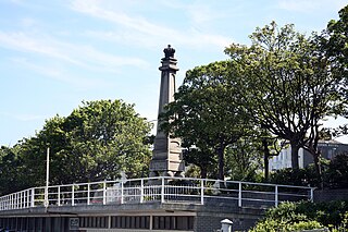
| Descrizione | Dun Laoghaire is a very historical town. It used to be a small fishing village located on a rocky coast near Salthill, which was renowned for its production of salt. The original village, called Dunleary was situated near the beginning of the present West Pier. The present inner harbour, known as the coal harbour, dates from that time of the 18th Century. It consisted of seventy dwellings or cottages and was a very compact little village. All that remains of Dunleary is a row of 15 houses, including ‘Purty Kitchen’ and the Coal Harbour Pier. However, during that time, there was also another pier which was in the form of a curve. That pier is now buried beneath the railway line. There used to be a sandy cove running up to the site of the former ‘Fun Factory’, which was closed recently. Now, all that land has been reclaimed and built on. In Dunleary during the 18th Century, there used to be a famous coffeehouse which was very popular with tourists and people on day-trips from Dublin. The small harbour used to dry-out at low tide but it was considered an important departure point for England. Dun Laoghaire is still an important port, however the present journey time of 1½ hours does not compare to the 22 hours then! |
| Data | |
| Fonte | DUN LAOGHAIRE |
| Autore | William Murphy from Dublin, Ireland |
Licenza
Questo file è disponibile in base alla licenza Creative Commons Attribuzione-Condividi allo stesso modo 2.0 Generico
- Tu sei libero:
- di condividere – di copiare, distribuire e trasmettere quest'opera
- di modificare – di adattare l'opera
- Alle seguenti condizioni:
- attribuzione – Devi fornire i crediti appropriati, un collegamento alla licenza e indicare se sono state apportate modifiche. Puoi farlo in qualsiasi modo ragionevole, ma non in alcun modo che suggerisca che il licenziante approvi te o il tuo uso.
- condividi allo stesso modo – Se remixi, trasformi o sviluppi il materiale, devi distribuire i tuoi contributi in base alla stessa licenza o compatibile all'originale.
| Questa immagine è stata originariamente caricata su Flickr da infomatique all'indirizzo https://www.flickr.com/photos/80824546@N00/190196802. È stata controllata in data 24 maggio 2007 dal robot FlickreviewR ed è stato confermato il suo rilascio sotto i termini della licenza cc-by-sa-2.0. |
Cronologia del file
Fare clic su un gruppo data/ora per vedere il file come si presentava nel momento indicato.
| Data/Ora | Miniatura | Dimensioni | Utente | Commento | |
|---|---|---|---|---|---|
| attuale | 10:39, 24 mag 2007 | | 2 048 × 1 365 (1,09 MB) | Kanchelskis | {{Information |Description= Dun Laoghaire is a very historical town. It used to be a small fishing village located on a rocky coast near Salthill, which was renowned for its production of salt. The original village, called Dunleary was situated near the b |
Pagine che usano questo file
La seguente pagina usa questo file:
Utilizzo globale del file
Anche i seguenti wiki usano questo file:
- Usato nelle seguenti pagine di af.wikipedia.org:
- Usato nelle seguenti pagine di en.wikipedia.org:
- Usato nelle seguenti pagine di es.wikipedia.org: