File proveniente da Wikimedia Commons. Clicca per visitare la pagina originale

File:Concord Expedition and Patriot Messengers.jpg

Da Wikipedia, l'enciclopedia libera.
Vai alla navigazione Vai alla ricerca

File originale(1 000 × 426 pixel, dimensione del file: 139 KB, tipo MIME: image/jpeg)

Logo di Commons
Logo di Commons
Questo file e la sua pagina di descrizione (discussione · modifica) si trovano su Wikimedia Commons (?)
Questo file è stato rimpiazzato da File:Concord Expedition and Patriot Messengers-en.svg. Si raccomanda di usare l'altro file. Per favore ricorda che la cancellazione di immagini rimpiazzate è soggetta a consenso.
new file
File:Concord Expedition and Patriot Messengers-en.svg è una versione vettoriale di questo file. Dovrebbe essere usata quella versione al posto di questo file JPG, quando sia migliore.

File:Concord Expedition and Patriot Messengers.jpg → File:Concord Expedition and Patriot Messengers-en.svg

Per maggiori informazioni, vedi Help:SVG.

In altre lingue
Alemannisch  Bahasa Indonesia  Bahasa Melayu  British English  català  čeština  dansk  Deutsch  eesti  English  español  Esperanto  euskara  français  Frysk  galego  hrvatski  Ido  italiano  lietuvių  magyar  Nederlands  norsk bokmål  norsk nynorsk  occitan  Plattdüütsch  polski  português  português do Brasil  română  Scots  sicilianu  slovenčina  slovenščina  suomi  svenska  Tiếng Việt  Türkçe  vèneto  Ελληνικά  беларуская (тарашкевіца)  български  македонски  нохчийн  русский  српски / srpski  татарча/tatarça  українська  ქართული  հայերեն  বাংলা  தமிழ்  മലയാളം  ไทย  한국어  日本語  简体中文  繁體中文  עברית  العربية  فارسی  +/−
Nuova immagine SVG

Dettagli

Titolo
inglese:
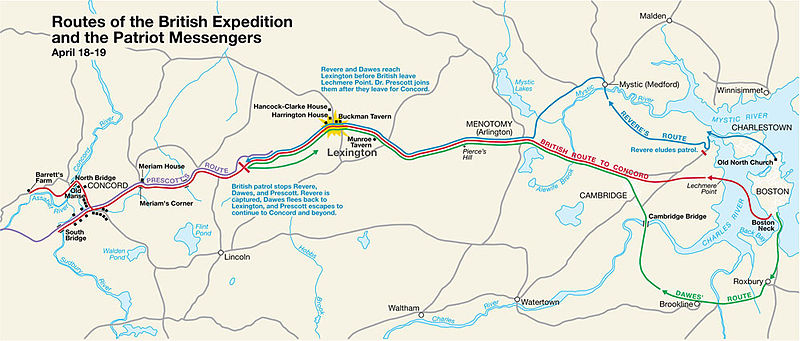
Routes of the British Expedition and the Patriot Messengers
title QS:P1476,en:"Routes of the British Expedition and the Patriot Messengers"
label QS:Len,"Routes of the British Expedition and the Patriot Messengers"
Descrizione
Paul Revere's Midnight Ride
English: This is a map depiction the outbound routes taken by Patriot riders and British troops in the Battles of Lexington and Concord on April 19, 1775.
Map legend
 
British route to Concord
 
Revere's route
 
Dawes' route
 
Prescott's route
Data Data sconosciuta
Unknown date
; source PDF was created in 2000
Fonte MIMAmap2.pdf 10 maggio 2005 (data di caricamento) di w:Flying Jazz (discussione | contributi)
Creatore
SconosciutoUnknown author for National Park Service
 Geotemporal data
Data rappresentata
Map location Boston, Massachusetts
Map type thematic map
Heading
Georeferencing Georeference the map in Wikimaps Warper If inappropriate please set warp_status = skip to hide.
 Bibliographic data
Casa editrice
National Park Service
 Archival data
institution QS:P195,Q308439
Iscrizioni

Titolo in alto a sinistra:

Routes of the British Expedition and the Patriot Messengers
Testo al centro:
Revere and Dawes reach Lexington before British leave Lechmere Point. Dr. Prescott joins them after they leave for Concord.
Testo al centro:
British patrol stops Revere, Dawes, and Prescott. Revere is captured, Dawes flees back to Lexington, and Prescott escapes to continue to Concord and beyond.
Altre versioni


Licenza

Public domain This image or media file contains material based on a work of a National Park Service employee, created as part of that person's official duties. As a work of the U.S. federal government, such work is in the public domain in the United States. See the NPS website and NPS copyright policy for more information.


Registro originale del caricamento

Trasferito da en.wikipedia su Commons da Andrei Stroe utilizzando CommonsHelper.

La pagina di descrizione originale era qui. Tutti i nomi utente che seguono sono riferiti a en.wikipedia.
  • 2005-05-10 09:58 Flying Jazz 1000×426× (141988 bytes) Routes of the British Expedition and the Patriot Messengers April 18-19 (1775) Minute Man National Historical Park Battle Map http://data2.itc.nps.gov/parks/mima/ppMaps/MIMAmap2.pdf {{PD-USGov-Interior-NPS}}
  • 2005-05-10 09:54 Flying Jazz 1000×426× (141988 bytes) Minute Man National Historical Park Battle Map http://data2.itc.nps.gov/parks/mima/ppMaps/MIMAmap2.pdf {{PD-USGov-Interior-NPS}}

Didascalie

Aggiungi una brevissima spiegazione di ciò che questo file rappresenta

Elementi ritratti in questo file

raffigura

image/jpeg

6d41ba675801bcccac169e02d6a8af6c7c2b117e

141 988 byte

426 pixel

1 000 pixel

Cronologia del file

Fare clic su un gruppo data/ora per vedere il file come si presentava nel momento indicato.

Data/OraMiniaturaDimensioniUtenteCommento
attuale22:50, 22 nov 2010Miniatura della versione delle 22:50, 22 nov 20101 000 × 426 (139 KB)File Upload Bot (Magnus Manske) {{BotMoveToCommons|en.wikipedia|year={{subst:CURRENTYEAR}}|month={{subst:CURRENTMONTHNAME}}|day={{subst:CURRENTDAY}}}} {{Information |Description={{en|This is a map depiction the outbound routes taken by Patriot ride

La seguente pagina usa questo file:

Utilizzo globale del file

Anche i seguenti wiki usano questo file:

Metadati