File:BlankMap-World6 steradian.svg
Vai alla navigazione
Vai alla ricerca

Dimensioni di questa anteprima PNG per questo file SVG: 800 × 411 pixel. Altre risoluzioni: 320 × 164 pixel | 640 × 329 pixel | 1 024 × 526 pixel | 1 280 × 657 pixel | 2 560 × 1 314 pixel | 863 × 443 pixel.
File originale (file in formato SVG, dimensioni nominali 863 × 443 pixel, dimensione del file: 1,58 MB)
| Questo file e la sua pagina di descrizione (discussione · modifica) si trovano su Wikimedia Commons (?) |
Dettagli
| Descrizione |
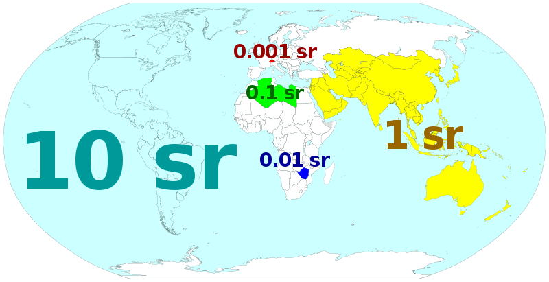
English: Illustration of solid angle of countries and other entities relative to the Earth. ---- W3C-validity not checked. |
| Data | (UTC) |
| Fonte |
Questo file deriva da: BlankMap-World6.svg: |
| Autore |
|
| Questa è una immagine ritoccata, il che significa che è stata modificata digitalmente dalla sua versione originale. Modifiche: Colour selected countries. La versione originale può essere vista qui: BlankMap-World6.svg. Le modifiche sono di Cmglee.
|
Licenza
Io, detentore del copyright su quest'opera, dichiaro di pubblicarla con la seguente licenza:
| Io, detentore del copyright su quest'opera, la rilascio nel pubblico dominio. Questa norma si applica in tutto il mondo. In alcuni paesi questo potrebbe non essere legalmente possibile. In tal caso: Garantisco a chiunque il diritto di utilizzare quest'opera per qualsiasi scopo, senza alcuna condizione, a meno che tali condizioni siano richieste dalla legge. |
Registro originale del caricamento
This image is a derivative work of the following images:
- File:BlankMap-World6.svg licensed with PD-self
- 2012-02-14T13:37:02Z Tentotwo 863x443 (1609186 Bytes) Removed hardcoded styles from sd, ss, and cf
- 2012-01-06T03:22:35Z Spesh531 863x443 (1651067 Bytes) Fixing South Sudan's border
- 2011-12-19T00:04:12Z Chipmunkdavis 863x443 (1612580 Bytes) Reverted to version as of 00:51, 27 August 2011
- 2011-12-18T15:14:45Z Anshulkumardhiman 1920x1080 (320804 Bytes) fixed background
- 2011-12-18T15:06:50Z Anshulkumardhiman 1920x1080 (323987 Bytes) fixed color texture
- 2011-08-27T00:51:14Z Anomie 863x443 (1612580 Bytes) South Sudan has been assigned code SS, so use that code.
- 2011-07-30T18:04:36Z Lokal Profil 863x443 (1612578 Bytes) Minor circle related changes and remove the legacy pentagram
- 2011-07-08T23:26:24Z NuclearVacuum 863x443 (1613386 Bytes) South Sudan is free!! Hooray
- 2011-07-04T20:41:30Z NuclearVacuum 863x443 (1615589 Bytes) Restored to previous version, as SS isn't independent yet. But the code is now ready and waiting
- 2011-07-04T20:40:06Z NuclearVacuum 863x443 (1613386 Bytes) Separated South Sudan from (North) Sudan in preparation for SS independence on July 9, 2011.
- 2011-06-27T15:15:14Z Canuckguy 863x443 (1615589 Bytes) restored PR, set id labels for West Bank and Gaza
- 2011-04-01T14:09:57Z NuclearVacuum 863x443 (1614917 Bytes) Mayotte is now a department of France
- 2011-02-17T14:31:36Z NuclearVacuum 863x443 (1614903 Bytes) minor fixes
- 2011-02-13T01:43:20Z Canuckguy 863x443 (1632654 Bytes) minor fix
- 2011-01-22T20:16:24Z NuclearVacuum 863x443 (1614900 Bytes) added lakes
- 2011-01-22T20:12:02Z NuclearVacuum 863x443 (1632622 Bytes) ...
- 2011-01-22T20:08:04Z NuclearVacuum 863x443 (1632651 Bytes) Reverted to version as of 18:31, 17 January 2011
- 2011-01-22T20:07:39Z NuclearVacuum 1173x937 (334238 Bytes) just testing something
- 2011-01-17T18:31:33Z NuclearVacuum 863x443 (1632651 Bytes) minor fix of Sudan
- 2011-01-17T18:26:18Z NuclearVacuum 863x443 (1632651 Bytes) minor fix
- 2011-01-17T18:17:24Z NuclearVacuum 863x443 (1632633 Bytes) clean code
- 2011-01-17T18:12:07Z NuclearVacuum 863x443 (1632625 Bytes) added new class of circles, added Southern Sudan as a region within Sudan.
- 2011-01-15T00:06:15Z NuclearVacuum 863x443 (1631574 Bytes) minor fix
- 2011-01-14T23:51:44Z NuclearVacuum 863x443 (1631571 Bytes) added missing regions of the European Union
- 2011-01-13T14:26:50Z NuclearVacuum 863x443 (1631559 Bytes) minor fix
- 2011-01-13T14:17:57Z NuclearVacuum 863x443 (1631550 Bytes) added the BES Islands to the Netherladns
- 2011-01-07T21:02:08Z NuclearVacuum 863x443 (1631333 Bytes) minor fix
- 2011-01-07T20:55:32Z NuclearVacuum 863x443 (1631333 Bytes) corrected code for the circles
- 2011-01-06T16:44:29Z NuclearVacuum 863x443 (1208206 Bytes) removed all but 5px of whitespace, see talk page
- 2011-01-03T14:03:40Z NuclearVacuum 854x433 (1208195 Bytes) Curaçao and Sint Maarten have been given codes
- 2011-01-02T03:21:03Z Tomchen1989 854x433 (1205379 Bytes) compromised for the bug
- 2010-12-28T01:58:24Z Kintetsubuffalo 853x433 (1205378 Bytes) what are you talking about? nothing is cut off or squished
- 2010-12-28T00:28:42Z NuclearVacuum 940x477 (1631321 Bytes) Reverted to version as of 16:43, 27 October 2010
- 2010-12-19T20:10:58Z Tomchen1989 853x433 (1205378 Bytes) stroke-width of coast
- 2010-12-19T08:51:57Z Tomchen1989 853x433 (1205378 Bytes) minor change
- 2010-12-16T16:14:47Z Tomchen1989 853x433 (1205378 Bytes) radius of the circles changed
- 2010-12-14T22:57:20Z Tomchen1989 853x433 (1208461 Bytes) small fixed
- 2010-12-14T22:36:00Z Tomchen1989 853x433 (1208830 Bytes) had outside whitespace removed; cleaned the code; used tab indent
- 2010-10-27T16:43:23Z NuclearVacuum 940x477 (1631321 Bytes) fixed as part of discussion
- 2010-10-24T03:54:05Z NuclearVacuum 940x477 (1630960 Bytes) I fixed the code so it is valid
- 2010-10-10T22:06:16Z Canuckguy 940x477 (1630991 Bytes) Reverted to version as of 02:01, 18 September 2010 (Neth. Antilles removed, Sint Maarten and Curacao added, Bonaire part of "nl")
- 2010-09-18T02:01:50Z Canuckguy 940x477 (1630802 Bytes) Reverted to version as of 01:03, 9 July 2010. New version to be used October 10, 2010
- 2010-09-18T02:01:03Z Canuckguy 940x477 (1630991 Bytes) version with Sint Maarten and Curacao added, Bonaire as part of Netherlands, and Netherlands Antilles removed. To be used starting October 10, 2010
- 2010-07-09T01:03:28Z NuclearVacuum 940x477 (1630802 Bytes) after thinking about it, I think "aa" is better for the ocean than "zz"
- 2010-07-07T21:49:57Z NuclearVacuum 940x477 (1630805 Bytes) Reverted to version as of 20:25, 7 July 2010
- 2010-07-07T21:49:26Z NuclearVacuum 940x477 (1629207 Bytes) Reverted to version as of 16:45, 25 June 2010
- 2010-07-07T21:48:28Z NuclearVacuum 940x477 (1630623 Bytes) Reverted to version as of 16:51, 29 June 2010 checking
- 2010-07-07T21:47:19Z NuclearVacuum 940x477 (1630506 Bytes) Reverted to version as of 14:49, 1 July 2010 checking something
- 2010-07-07T20:25:43Z NuclearVacuum 940x477 (1630805 Bytes) added marker for Swaziland
- 2010-07-07T19:43:09Z NuclearVacuum 940x477 (1630656 Bytes) added the European Union
Uploaded with derivativeFX
Cronologia del file
Fare clic su un gruppo data/ora per vedere il file come si presentava nel momento indicato.
| Data/Ora | Miniatura | Dimensioni | Utente | Commento | |
|---|---|---|---|---|---|
| attuale | 16:34, 23 feb 2023 | | 863 × 443 (1,58 MB) | Iktsokh | Clearing the map |
| 23:10, 8 mag 2012 |  | 863 × 443 (1,54 MB) | Cmglee | Add labels and update 1 sr region. | |
| 21:18, 8 mag 2012 |  | 863 × 443 (1,54 MB) | Cmglee | Update to match table on ''steradian''. | |
| 20:49, 17 feb 2012 |  | 863 × 443 (1,53 MB) | Cmglee | == {{int:filedesc}} == {{Information |Description={{en|1=Illustration of solid angle of countries and other entities relative to the Earth.}} ---- {{ValidSVG}} |Source={{Derived from|BlankMap-World6.svg|display=50}} |Date=2012-02-17 18:48 (UTC) |Author=*[ |
Pagine che usano questo file
La seguente pagina usa questo file:
Utilizzo globale del file
Anche i seguenti wiki usano questo file:
- Usato nelle seguenti pagine di cv.wikipedia.org:
- Usato nelle seguenti pagine di en.wikipedia.org:
- Usato nelle seguenti pagine di ml.wikipedia.org:
- Usato nelle seguenti pagine di mn.wikipedia.org:
- Usato nelle seguenti pagine di ru.wikipedia.org:
- Usato nelle seguenti pagine di sr.wikipedia.org: