File:Battle of Broodseinde - situation map.jpg
Vai alla navigazione
Vai alla ricerca

Dimensioni di questa anteprima: 785 × 600 pixel. Altre risoluzioni: 314 × 240 pixel | 628 × 480 pixel | 1 005 × 768 pixel | 1 280 × 978 pixel | 2 560 × 1 956 pixel | 6 727 × 5 139 pixel.
File originale (6 727 × 5 139 pixel, dimensione del file: 10,64 MB, tipo MIME: image/jpeg)
| Questo file e la sua pagina di descrizione (discussione · modifica) si trovano su Wikimedia Commons (?) |
Dettagli
| Titolo |
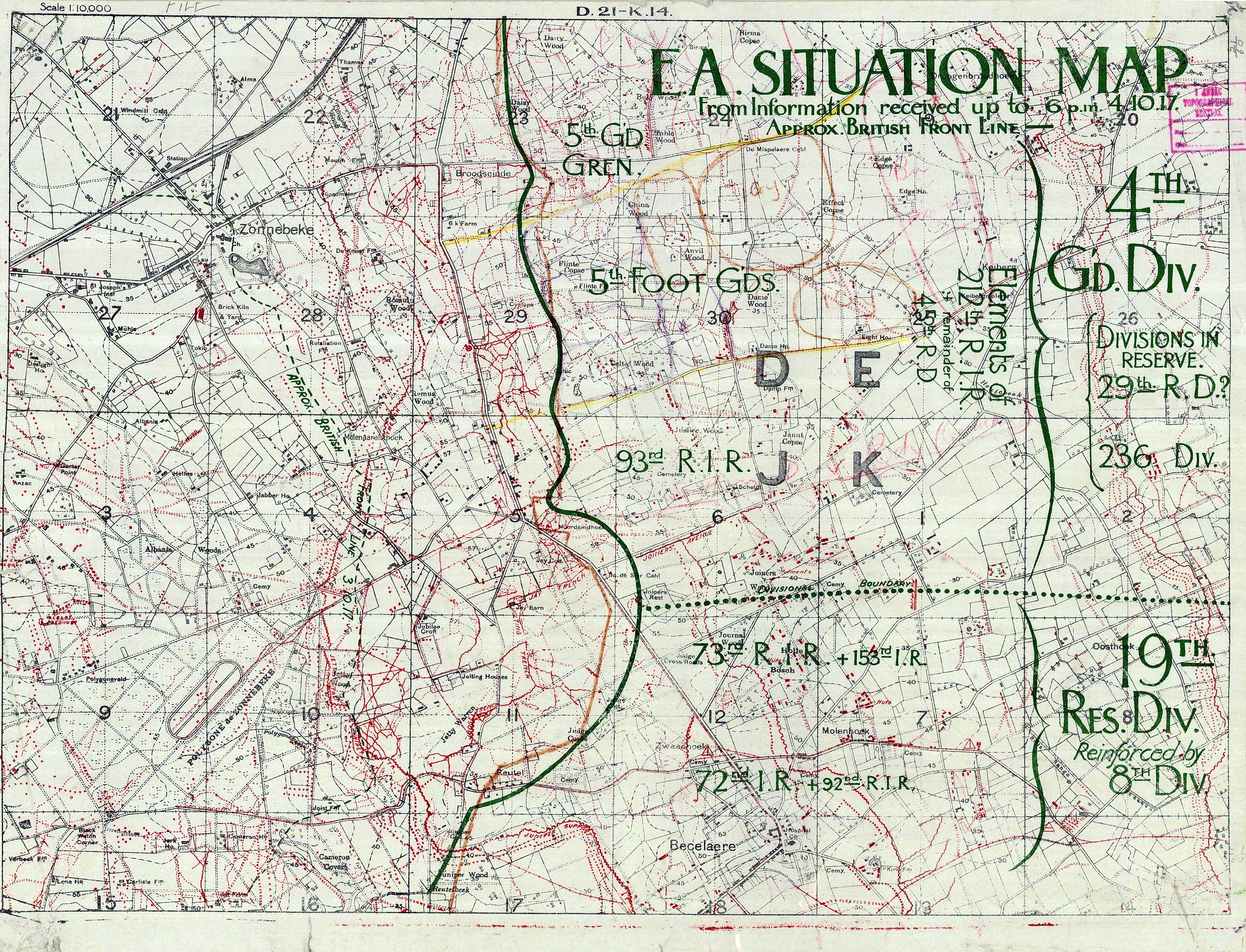
English: E.A. situation map : from information received up to 6 p.m., 4.10.17 [overprinted on] D.21 - K.14 |
|||||||||||||||||||||||
| Descrizione |
English: 1:10000 scale situation map from the Battle of Broodseinde during the Third Battle of Ypres. Overprinted to show the British front line and disposition of German forces as of 4 October 1917. Shows also the advance made in the British front line between 3 and 4 October. |
|||||||||||||||||||||||
| Data | ||||||||||||||||||||||||
| Fonte |
|
|||||||||||||||||||||||
| Creatore |
Anzac Corps, 1st. Topographical Section.; Great Britain. Army Printing and Stationery Services |
|||||||||||||||||||||||
| Licenza (Riusare questo file) |
|
|||||||||||||||||||||||
| Geotemporal data | ||||||||||||||||||||||||
| Data rappresentata | ||||||||||||||||||||||||
| Map location | Zonnebeke | |||||||||||||||||||||||
| Map type | trench map | |||||||||||||||||||||||
| Scala | 1:10000 | |||||||||||||||||||||||
| Heading |
 |
|||||||||||||||||||||||
| Bounding box |
|
|||||||||||||||||||||||
| Georeferencing | ||||||||||||||||||||||||
| Bibliographic data | ||||||||||||||||||||||||
| Map sheet | G5831.S65 Sheet 14.17.6 | |||||||||||||||||||||||
| Lingua | inglese | |||||||||||||||||||||||
| Casa editrice |
Anzac Corps, 1st. Topographical Section. |
|||||||||||||||||||||||
| Archival data | ||||||||||||||||||||||||
| Collezione |
|
|||||||||||||||||||||||
| Dimensioni | altezza: 52 cm; larghezza: 55 cm | |||||||||||||||||||||||


Cronologia del file
Fare clic su un gruppo data/ora per vedere il file come si presentava nel momento indicato.
| Data/Ora | Miniatura | Dimensioni | Utente | Commento | |
|---|---|---|---|---|---|
| attuale | 02:52, 5 giu 2018 | | 6 727 × 5 139 (10,64 MB) | Labattblueboy | tone |
| 21:44, 30 ott 2009 |  | 6 727 × 5 139 (9,6 MB) | Labattblueboy | {{Information |Description=1:10000 scale situation map from the Battle of Broodseinde during the Third Battle of Ypres. The map shows the position of local German units and formations |Source=Exerpt from Australian War Memorial (www.awm.gov.au)<br>http:/ |
Pagine che usano questo file
La seguente pagina usa questo file:
Utilizzo globale del file
Anche i seguenti wiki usano questo file:
- Usato nelle seguenti pagine di en.wikipedia.org: