File:Übersichtskarte Loveparade Duisburg 2010.jpg
Vai alla navigazione
Vai alla ricerca
Non sono disponibili versioni a risoluzione più elevata.
Übersichtskarte_Loveparade_Duisburg_2010.jpg (400 × 400 pixel, dimensione del file: 105 KB, tipo MIME: image/jpeg)
| Questo file e la sua pagina di descrizione (discussione · modifica) si trovano su Wikimedia Commons (?) |

|
Questa immagine (categorizzazione automatica: road map) o tutte le immagini in questa categoria o galleria dovrebbero essere ricreate usando grafica vettoriale come file SVG. Questo offre diversi vantaggi: vedi Commons:Media for cleanup per maggiori informazioni. Se è disponibile una versione in formato SVG di questa immagine, per favore caricala. Dopo aver caricato un file SVG, sostituisci questo avviso con il template {{Vector version available|nome_immagine.svg}}.
|


| Descrizione |
English: Overview on loveparade 2010 in Duisburg |
|||||
| Data | ||||||
| Fonte | Opera propria, based on OpenStreetMap data published under CC-BY-SA 2.0 | |||||
| Autore | user:axpde | |||||
| Licenza (Riusare questo file) |
|

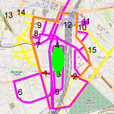
| Farbe / Ziffer | Erklärung | Explanation | Ort |
|---|---|---|---|
| Rot | Sicherheitsschleusen | security ports | |
| Orange | Geplante Fußwege | planned Footpaths | |
| Gelb | Tatsächliche genutzte Wege | actually used paths | |
| Magenta | Rettungswege | emergency paths | |
| Grün | Festivalgelände | festival area | |
| 1 | Westliche Sicherheitsschleuse | western security port | Karl-Lehr-Straße / Düsseldorfer Straße |
| 2 | Östliche Sicherheitsschleuse | eastern security port | Karl-Lehr-Straße / Grabenstraße |
| 3 | Haupteingang (zwei 20 m breite Tunnel, eine 50 m breite Rampe) | main entry (two tunnel of 20 m width, a ramp of 50 m width) | Karl-Lehr-Straße |
| 4 | VIP-Eingang / nördlicher Rettungsweg | VIP entry / northern escape way | Am Güterbahnhof |
| 5 | Südlicher Rettungsweg / Sanitätsdienst | southern escape way / medical service | Grunewald |
| 6 | Bethesda-Johanniter-Klinikum | Bethesda Hospitaller clinical center | |
| 7 | VIP-Eingang / Sanitätsdient | VIP entry / medical service | Mercatorstraße |
| 8 | Sanitätsdienstzentrale | central medical service | Steinbart-Gymnasium |
| 9 | Behelfshubschrauberlandeplatz | emergency heliport | Kantpark |
| 10 | Sanitätsdienst | medical service | Kammerstraße, Gertrud-Bäumer-Schule |
| 11 | Behelfshubschrauberlandeplatz | emergency heliport | Ludgeriplatz |
| 12 | Duisburg Hauptbahnhof | Duisburg central station | |
| 13 | Zentraler Omnibusbahnhof / U-Bahnhof | central bus station / underground station | Steinsche Gasse |
| 14 | „Nebenschauplatz“ | „Sideshow“ | Friedrich-Wilhelm-Platz |
| 15 | „Nebenschauplatz“ | „Sideshow“ | Neudorfer Markt |
Cronologia del file
Fare clic su un gruppo data/ora per vedere il file come si presentava nel momento indicato.
| Data/Ora | Miniatura | Dimensioni | Utente | Commento | |
|---|---|---|---|---|---|
| attuale | 19:01, 27 lug 2010 | | 400 × 400 (105 KB) | Axpde | some additions |
Pagine che usano questo file
La seguente pagina usa questo file:
Utilizzo globale del file
Anche i seguenti wiki usano questo file:
- Usato nelle seguenti pagine di ar.wikipedia.org:
- Usato nelle seguenti pagine di bg.wikipedia.org:
- Usato nelle seguenti pagine di ca.wikipedia.org:
- Usato nelle seguenti pagine di de.wikipedia.org:
- Usato nelle seguenti pagine di en.wikipedia.org:
- Usato nelle seguenti pagine di fi.wikipedia.org:
- Usato nelle seguenti pagine di id.wikipedia.org:
- Usato nelle seguenti pagine di nds.wikipedia.org:
- Usato nelle seguenti pagine di nl.wikipedia.org:
- Usato nelle seguenti pagine di ru.wikipedia.org:
- Usato nelle seguenti pagine di vec.wikipedia.org:
- Usato nelle seguenti pagine di www.wikidata.org: