File:Central and Eastern Europe around 950 AD.png
Vai alla navigazione
Vai alla ricerca
Non sono disponibili versioni a risoluzione più elevata.
Central_and_Eastern_Europe_around_950_AD.png (628 × 525 pixel, dimensione del file: 272 KB, tipo MIME: image/png)
| Questo file e la sua pagina di descrizione (discussione · modifica) si trovano su Wikimedia Commons (?) |

Dettagli
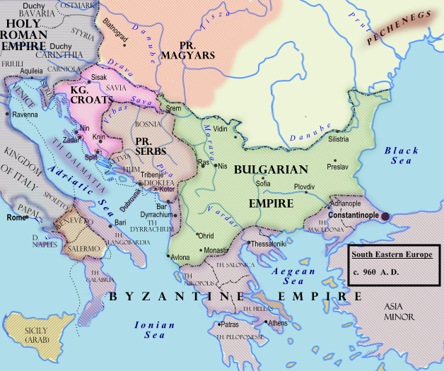
| Descrizione |
Български: Политическа география на сръбските земи при Чеслав Клонимирович.
English: Southeastern Europe around 950 AD
Español: Europa del Sudeste, hacia 960.
Français : Europe du Sud-Est vers 950 à la mort de Caslav.
Hrvatski: Jugoistočna Europa oko 950. godine.
Română: 950.
Српски / srpski: Оквирни приказ граница на Балкану (око 960. године), крајем Чаславове владавине. |
| Data | 7 febbraio 2009 (data di caricamento originaria) |
| Fonte |
Trasferito da en.wikipedia su Commons.
|
| Autore | Hxseek di Wikipedia in inglese |
![[3]](http://www.lib.utexas.edu/maps/historical/shepherd/europe_byzantine_empires.jpg)
Licenza
| Quest'opera è stata rilasciata nel pubblico dominio dal suo autore, Hxseek di Wikipedia in inglese. Questa norma si applica in tutto il mondo. In alcuni paesi questo potrebbe non essere legalmente possibile. In tal caso: Hxseek garantisce a chiunque il diritto di utilizzare quest'opera per qualsiasi scopo, senza alcuna condizione, a meno che tali condizioni siano richieste dalla legge. |
Registro originale del caricamento
La pagina di descrizione originale era qui. Tutti i nomi utente che seguono sono riferiti a en.wikipedia.
- 2009-02-07 03:50 Hxseek 628×525× (278873 bytes)
Cronologia del file
Fare clic su un gruppo data/ora per vedere il file come si presentava nel momento indicato.
| Data/Ora | Miniatura | Dimensioni | Utente | Commento | |
|---|---|---|---|---|---|
| attuale | 12:07, 26 mar 2009 | | 628 × 525 (272 KB) | Captain-tucker | {{Information |Description={{en|== Licensing: ==}} |Source=Transferred from [http://en.wikipedia.org en.wikipedia] |Date=2009-02-07 (original upload date) |Author=Original uploader was Hxseek at [http://en.wikipedia.org en.wikipedia] | |
Pagine che usano questo file
Le seguenti 6 pagine usano questo file:
Utilizzo globale del file
Anche i seguenti wiki usano questo file:
- Usato nelle seguenti pagine di azb.wikipedia.org:
- Usato nelle seguenti pagine di be-tarask.wikipedia.org:
- Usato nelle seguenti pagine di be.wikipedia.org:
- Usato nelle seguenti pagine di bg.wikipedia.org:
- Usato nelle seguenti pagine di el.wikipedia.org:
- Usato nelle seguenti pagine di en.wikipedia.org:
- Usato nelle seguenti pagine di es.wikipedia.org:
- Usato nelle seguenti pagine di et.wikipedia.org:
- Usato nelle seguenti pagine di fi.wikipedia.org:
- Usato nelle seguenti pagine di fr.wikipedia.org:
- Usato nelle seguenti pagine di gl.wikipedia.org:
- Usato nelle seguenti pagine di hu.wikipedia.org:
- Usato nelle seguenti pagine di lt.wikipedia.org:
- Usato nelle seguenti pagine di lv.wikipedia.org:
- Usato nelle seguenti pagine di mk.wikipedia.org:
- Usato nelle seguenti pagine di pl.wikipedia.org:
- Usato nelle seguenti pagine di pt.wikipedia.org:
- Usato nelle seguenti pagine di ro.wikipedia.org:
- Usato nelle seguenti pagine di ru.wikipedia.org:
- Usato nelle seguenti pagine di sh.wikipedia.org:
- Usato nelle seguenti pagine di sl.wikipedia.org:
- Usato nelle seguenti pagine di sr.wikipedia.org:
- Usato nelle seguenti pagine di th.wikipedia.org:
- Usato nelle seguenti pagine di uk.wikipedia.org: